


KEY HIGHLIGHTS
-
The first phase (P1) of detailed mapping and rock sampling has been completed on the Ecru Gold Project
-
Mapping identified areas of strong hornfelsing, brecciation and silicification as well as structural controls to the alteration patterns.
-
Hornfels is a critical indicator for Robertson-style gold mineralisation
-
About 100 rock samples were collected and will be sent for multi-element laboratory analysis.
“Detailed mapping and sampling of any project are key tasks that must be completed to understand the mineralisation characteristics and potential of any project. We are very pleased with the geological alteration characteristics identified on Ecru.
Hornfelsing is a genetic and spatial indicator of the intrusion, a deposit-type classifier and potentially a geochemical facilitator of gold deposition. Its presence is critical, and it represents a positive step forward in the Ecru exploration plan.” – Johan Lambrechts (CEO)
Vancouver, British Columbia–(Newsfile Corp. – June 17, 2026) – Aurbis Resources Corp. (CSE: AURR) (Aurbis, AURR or the Company) is pleased to announce that the first phase of mapping and rock sampling (P1) has been completed on the Ecru Gold Project, held by Aurbis Resources in Lander County, Nevada.
The mapping project identified several Robertson-Style characteristics in an area interpreted as the contact aureole of the Ecru intrusion. These characteristics included areas of intense hornfelsing, brecciation, and silicification, all of which are associated with the Robertson-Style intrusion-related gold mineralisation.
Robertson-Style mineralization is named for the Robertson deposit just 2 km away from Ecru. This 2.7-million-ounce1 gold discovery was acquired by Barrick in 2017 and is now headed to production under Nevada Gold Mines (Barrick/Newmont) within the famed Cortez Complex, one of the richest gold trends in the world.
The P1 mapping program focused on the southwestern portion of the Ecru project, where outcrop exists. About 150 rock samples were also collected during this phase of work and will be submitted to the analytical laboratory in Reno, Nevada.
The mapping and sampling program is aimed to better understand the alteration assemblage of the Ecru Gold Project in relation to the Robertson-Style intrusion-related gold mineralisation. The rock samples will undergo the full mineral suite analyses to support the visual geological mapping interpretations with geochemical data. The program data is being compiled and will be reviewed alongside the sample results. It is likely that a second phase of mapping and rock sampling will be undertaken in the near future.
Geological mapping at Ecru
A field mapping and outcrop sampling program was completed on the southwestern portion of the Ecru property, and about 100 rock chip samples were collected. The aim of the mapping and sampling program was to better understand the distribution of alteration assemblages on Ecru, particularly in relation to the interpreted intrusion identified by magnetic surveys.
A roughly north-striking fault divides the mapped area into two distinct zones. On the west of the fault, fine grey sandstone of the Elder formation is weakly altered and west-dipping. East of the fault, the rocks are intensely altered and south-dipping. East of the fault, a long exposure of brecciated, hornfelsed, interbedded Elder formation shows evidence of multiple phases of brecciation, where coarse, blocky collapse breccias are cut by strongly silicified, hydrothermal breccia. This hydrothermal breccia style was observed across multiple units over a wide area.
Strong hornfels alteration was observed in an interbedded unit within the Elder Formation consisting of laminated calcareous siltstone, clean quartz sandstone, and fine dark grey mudstone.
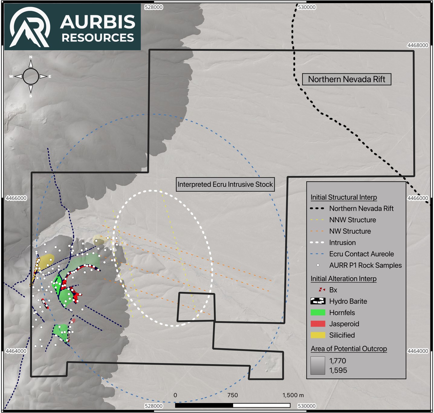
Figure 1: Map of the Ecru Gold Project indicating the Rock samples collected during the mapping program and the alteration zones identified
To view an enhanced version of this graphic, please visit:
https://images.newsfilecorp.com/files/8152/301838_a4624f1ff4bfba7e_004full.jpg
The ore deposits within the Tenabo district surrounding the Ecru project can be broadly characterized as hornfels or skarn systems associated with porphyry or reduced intrusion-related systems within the Tenabo pluton2. The mineralization style of Robertson, and therefore the target style at Ecru, is the hornfelsed zone associated with the contact aureole of a reduced intrusion. Hornfels is a significant and well-documented indicator characteristic at the Robertson deposit. Gold mineralisation at the Robertson Gold Deposit is associated with the contact metamorphism of the host siliciclastic rocks into calc-silicate hornfels, forming an aureole up to 1 km from the stock3.
In addition to the hornfelsing and brecciation, the mapping program identified several areas of jasper formation, silicification, and intense barite mineralization.
The jasper seems spatially associated with brecciation, and the barite zone was mapped along an outcrop of jasperoid breccia on the western edge of the mapping program. A zone of moderate-to-strong silicification associated with brecciation was mapped in the northwestern portion of the mapped area. All the zones of hornfelsing, brecciation, jasper formation, and silicification mapped on the Ecru project fall within an area less than 1 km from the intrusion and are therefore within the margins of the contact aureole as measured at the Robertson deposit. The contact aureole for each intrusion varies, but the identification of strong hornfelsing indicates that the mapped outcrops remain within the contact aureole of the Ecru intrusion.
The hornfels aureole is a mappable geological target. Identifying hornfels in the field signals proximity to the stock and the hydrothermal plumbing that might feed gold into the system.
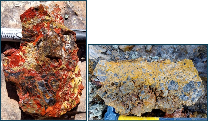
Figure 2: Photographs of rock samples collected on the Ecru project during the recent mapping program displaying red jasper formation and multiple phases of brecciation.
To view an enhanced version of this graphic, please visit:
https://images.newsfilecorp.com/files/8152/301838_aurbis1.jpg
Future Activities
Aurbis Resources Corp. (CSE: AURR) is pleased that the first phase of geological mapping and sampling on the Ecru Gold Project has been completed. It anticipates another P2 program to complete the northwestern portion of the outcropping area on Ecru. The samples collected during the mapping programs will be submitted to laboratories for a full suite of element analyses, and the results will be used in conjunction with existing data to further delineate future drill targets.
A high-definition magnetic survey has been completed, and the data will be inverted to produce a 3D view of the project’s magnetic characteristics and structurally interpreted to better understand potential fluid conduits. Once the magnetic interpretation is complete, that data will be used in conjunction with the 100m x 100m gravity data to model the project’s gravity characteristics. The combined data above will be used to generate initial targets, which will, in turn, guide a potential IP survey to identify clay alteration and/or sulfide mineralization. The final step, as envisaged by this exploration program, is drilling the targets identified by the culmination of the data.
We believe this is a robust exploration plan and gives the Company the best likelihood of success for discovery on the Ecru Gold Project.
We look forward to keeping our investors and followers informed of our progress.
On behalf of the Board of Directors
Johan Lambrechts
Chief Executive Officer and Director
1 (855) 764-2535
info@aurbisresources.com
The CSE has neither approved nor disapproved the contents of this news release. Neither the CSE nor its Market Regulator (as that term is defined in the policies of the CSE) accepts responsibility for the adequacy or accuracy of this release.
Footnotes:
1 Robertson Property historical inferred mineral resource estimate of ~2.7 Moz Au (191.7 Mt @ 0.0143 oz/t Au), per the NI 43-101 PEA dated January 15, 2012 prepared for Coral Gold Resources Ltd.
2 Exploring for structurally concealed Carlin-type mineralization: A case study from the northern Shoshone Range, Nevada, USA, Carson A. Richardson, Eric Seedorff
3 Paragenetic Evolution of the Robertson Deposit: Eocene Reduced Intrusion-Related Gold Deposit in the Northern Shoshone Range, Nevada, Mankins, Neal et al.
Qualified Person
Johan Lambrechts, QP, is the Company’s qualified person as defined by NI 43-101 and has reviewed the scientific and technical information that forms the basis for portions of this news release. Mr Lambrechts is a member of the Australian Institute of Geoscientists (#5900). He has approved the disclosure herein. Mr Lambrechts is not independent of the Company, as he is a director of the Company.
CAUTIONARY AND FORWARD-LOOKING STATEMENTS
This news release includes certain statements that may be deemed “forward-looking statements”. All statements in this news release, other than statements of historical facts that address events or developments that the Company expects to occur, are forward-looking statements.
Forward-looking statements are statements that are not historical facts and are generally, identified by the words “expects,” “plans,” “anticipates,” “believes,” “intends,” “estimates,” “projects,” “potential” and similar expressions, or that events or conditions “will,” “would,” “may,” “could” or “should” occur. Although the Company believes the expectations expressed in such forward-looking statements are based on reasonable assumptions, such statements are not guarantees of future performance.
Forward-looking statements are based on the beliefs, estimates, and opinions of the Company’s management on the date the statements are made. Except as required by applicable securities laws, the Company undertakes no obligation to update these forward-looking statements if management’s beliefs, estimates, opinions, or other factors.


