


Highlights:
-
Agreement to acquire up to 100% of the Lamont Lake Uranium exploration project in Saskatchewan, Canada
-
Saskatchewan is a highly prospective uranium province and favorable operating jurisdiction
-
Historical geological data from the project indicates shallow mineralization and potential for significant resource development
-
Historical shallow grade mineralization occurs from near surface to 57m and with grades of between 0.02% and 0.5% U3O8
-
Initial analysis of available geological data shows similarities to the Beaver lodge deposits, only 90km southeast of claims package
-
Minimal modern exploration undertaken across tenement package highlights near-term value creation opportunity
-
Lamont Lake Uranium Project provides exceptional optionality and is a complementary asset to the Company’s portfolio of clean energy assets
-
Management continues to review historical data associated with the project to define near term exploration program
Vancouver, British Columbia–(Newsfile Corp. – June 29, 2026) – DARK STAR MINERALS INC. (CSE: BATT) (WKN: A429LR) (FSE: P0W0) (the “Company” or “Dark Star”) is pleased to announce it has entered into an arm’s length, definitive agreement, dated June 26th, 2026, to acquire up to 100% of the Lamont Lake Uranium Project (the “Project”) situated in Northern Saskatchewan, Canada the terms of which are outlined below (the “Transaction”). The Project is located approximately 85km northwest of Uranium City, situated immediately north of the prolific Athabasca Basin, where some of the world’s highest-grade uranium deposits are located.
The Project encompasses 5 mineral claims covering an area of approximately 22km2. Based on historic drilling data, the project is situated in an area that contains shallow uranium mineralization, occurring from near-surface down to approximately 57m, with approximate grades of between 0.02% and 0.5% U3O8. The Project encompasses a landholding of 11 historic uranium occurrences, which include prospective historical assays and geological data.
Initial analysis of the Project indicates it has geological similarities to the Beaverlodge deposits area, located approximately 90km to the southeast. During its production life, the Beaverlodge deposits produced approximately 56Mlb U3O8 at an average grade of 0.24% U3O8 (Dieng S., Kyser K. and Godin L., 2015) . The company cautions that mineralization at Beaverlodge is not necessarily indicative of mineralization that may be identified on the Project.
The Project presents Dark Star with a compelling near-term exploration prospect and enhances diversification within the Company’s Uranium project portfolio.
The Company’s technical team continues to review historical exploration results and geological data associated with the claims portfolio, which will form the basis for an exploration program.
The Transaction
Pursuant to the mineral claim purchase option agreement, Dark Star Minerals Inc. has been granted the sole and exclusive option to acquire up to a 100% legal and beneficial interest in the mineral claims described in the agreement from Six (6) arms length vendors.
As consideration for the Option and upon the completion of all each of the (3) three tranches described below, Dark Star will issue an aggregate of 6,300,000 common shares, subject to resale restrictions of 4 months and a day from the date of issuance with a deemed price of $0.125. The consideration is payable in three equal tranches of 2,100,000 shares as follows:
-
2,100,000 shares upon execution of the agreement, subject to any required approvals;
-
2,100,000 shares on the earlier of 12 months from the effective date or the filing of an NI 43-101 technical report in respect of the project; and
-
2,100,000 shares 24 months from the effective date or execution date, unless otherwise amended by the parties in writing.
The option will be deemed exercised once Dark Star has completed all required share payments under the agreement. Upon exercise of the option, the optionor is required to execute and deliver all transfer documents and related authorizations necessary to transfer the claims to Dark Star or its designated affiliate.
During the option period, Dark Star will have the exclusive right to access, explore, sample, survey, map, inspect and otherwise evaluate the claims, subject to applicable laws, permits, surface access rights, environmental requirements and Indigenous consultation requirements.
Completion of the transaction, including the issuance of shares and transfer of the claims, remains subject to customary conditions, including receipt of all required records, securities, and completion of due diligence, and compliance with applicable securities laws.
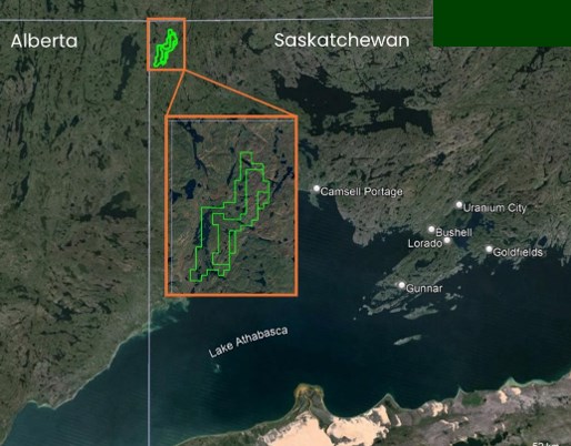
Figure 1. Lamont Lake Uranium Project Claims location
To view an enhanced version of this graphic, please visit:
https://images.newsfilecorp.com/files/9815/303310_d96ce95b04009b9c_002full.jpg
The Lamont Lake Uranium Project is located in Northern Saskatchewan, immediately north of the Athabasca Basin, one of the most important and prolific uranium districts in the world. Saskatchewan has a long history of uranium exploration and development, adding to Dark Star’s growing North American focused uranium exploration portfolio.
Marc Branson, Dark Star CEO and Director states: “Lamont Lake provides Dark Star with exposure to a prospective uranium land package that contains multiple historic, shallow uranium occurrences, meaningful historical exploration data and near-term exploration potential. Internal technical reviews reinforce the opportunity to apply modern exploration methods to an area that has seen limited recent work, despite encouraging historical results and geological characteristics that warrant follow-up. As global interest in secure, domestic and allied uranium supply continues to strengthen, we believe projects located in established North American jurisdictions will remain increasingly important. Our team is continuing to review the historical data from Lamont Lake and expects to finalize near-term exploration planning over the coming weeks. We look forward to updating shareholders as we advance the Project and continue evaluating additional strategic opportunities to strengthen Dark Star’s uranium portfolio.”
Historical Overview of the Lamont Lake Uranium Project
Dark Star is conducting technical reviews of historical exploration activities over the Project area, which was previously part of Permit N°4 (“Permit 4”). Permit 4 was acquired in 1966 by Numac Oil and Gas Limited (“Numac”), initially covering an area from Lake Athabasca through to British Columbia, Saskatchewan and the Northwest Territories border.1
An airborne radiometric survey was undertaken in 1967 over Permit 4. The airborne scintillometer survey, totaling 1,615 line-miles, was carried out by helicopter using a Mount Sopris Airborne Scintillation Detector and 5″ x 4″ Harshaw Sodium Iodide Scintillation Crystal Detector. The flight lines were oriented normal to the regional faulting, at a spacing of one-quarter mile and flown at 100 feet high. 2
In 1968, King Resources Company (“King Resources”) acquired claim blocks CBS 5535, CBS 5536 and CBS 5537, which are included in the Project area. King Resources completed an additional airborne radiometric survey over the area, which was subsequently prospected and airborne anomalies examined at ground level.3 Additionally, 347m of diamond drilling were carried out over the claim blocks, on what is now identified as the S3 anomaly.4
In 1977, Marubeni Canada Ltd (“Marubeni”) staked and was granted CBS 5535, CBS 5536 and CBS 5537. Geological mapping, prospecting and radiometric surveying in 1977, conducted by PNC Exploration (Canada) Co Ltd (“PNC”) on behalf of Marubeni, resulted in the discovery of a northerly trending uranium mineralized zone near the center of the claim blocks, east of Lamont Lake. In 1978, a trenching and drilling program of 13 holes (refer Figure 3), totaling 807m was completed. In 1979, the claims were transferred to PNC.5
The historical work on the Project area indicates significant radioactive areas and isolated occurrences, together with shallow mineralization down to a depth of approximately 57m, with approximate grades of between 0.02% and 0.5% U3O8.
There has been limited recent exploration activity undertaken on the Project. Historical exploration programs identified uranium mineralization, radiometric anomalies and alteration systems that warrant further evaluation. The Company believes the Project merits additional exploration to assess the extent and significance of these historical results
Mineralisation and Alteration
The Project encompasses 5 mineral claims, where historical exploration work and drilling have been undertaken, resulting in prospective historical assays and geological data.
Based on the airborne radiometric survey undertaken by Numac in 1967, significant radioactive areas and isolated occurrences were identified over the area, with a total of 48 anomalies located within Permit 4 and 11 specifically identified within the Project area.6
1 Assessment File Number: 74N12-0006
2 Assessment File Number: 74N12-0006
3 Assessment File Number: 74N12-0007 and Assessment File Number: 74N13-NW-0011
4 Assessment File Number: 74N13-NW-0011
5 Assessment file 74N13-NW-0011and Assessment File Number: 74N13-0013
6 Assessment File Number: 74N12-0006
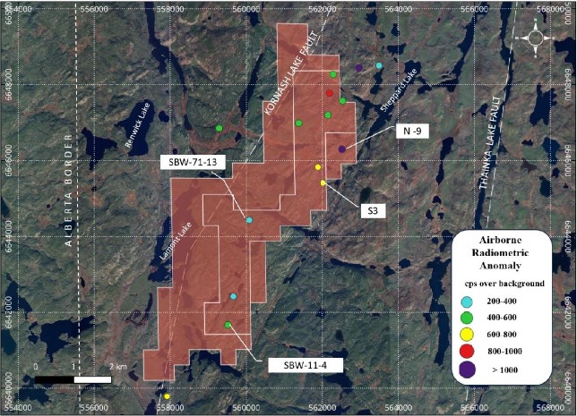
Figure 2. Airborne Radiometric Occurrences
To view an enhanced version of this graphic, please visit:
https://images.newsfilecorp.com/files/9815/303310_d96ce95b04009b9c_004full.jpg
From the available documentation, radioactive occurrences have the following characteristics.7
-
High Background: Areas of bedrock up to a few hundred square feet are often found to give count rates averaging between 150 and 500 counts per second (“cps”). Locations over l,000cps may be found but are not common. Host rocks are usually pink to red in color, indicating weak hematisation. Granite gneiss, mylonite, red crush-rock or cataclastic feldspar rock are the most common lithologies in which high background radioactivity is found.
-
Pegmatite Lenses: radioactivity is found in conformable quartz-rich pegmatite lenses or segregations in migmatite or quartz-feldspathic gneiss. Occurrences are erratic and narrow, with count rates generally less than 2,500cps; however, they may reach 10,000cps in certain locations. Yellow uranium oxides are common,
-
Radioactive Fractures: Radioactive fractures occur in up to three areas within the tenements. Pitchblende mineralization along fractures is the source of the radioactivity in the majority of the occurrences. Count rates may range from 500cps to over 15,000cps. Significant mineralization may be indicated if the fractures are spatially related to nearby faulting or if radioactive fractures are traceable over significant distances.
The mineralization over the area identified in the historical reports appears to consist predominantly of yellow uranium oxides and occurs as follows:8
-
Along north-south shear planes in the isoclinally folded pegmatitic feldspathic gneiss. The shear zones predominantly occur in biotite layers, and recrystallised biotite is coated with yellow uranium oxides. Drill hole N°5 in the S3 anomaly area intersected pitch-blended mineralization (0.51% over 0.5m from 30.0m), along a brecciated N-S fault zone.
-
Uranium minerals consisting of uraninite, uranophane and boltwoodite occur in the concordant pegmatites, along major fractures and near the grain boundaries
-
Minor radioactivity is associated with east-west fault systems. In 1968, King Resources tested the east-west fault systems in the S3 Anomaly area with a diamond drill program. Drill hole 68-K10-2 intersected elevated radioactivity from 179.25 – 222.25 feet.
In the South Kornash and SBW 71-13 Anomaly areas, the concordant nature of pegmatites with the associated radioactivity suggests the sedimentary origin for Uranium mineralization. The mineralization is sporadic, varying from a few metres long to a few metres wide in the South Kornash area to several hundred metres long and 50 metres wide in the SBW 71-13 anomaly area.
Mineralization is almost always associated with supergene or hydrothermal alteration. The alteration consists of a propylitic zone (chloritisation and epidotisation) and an argilitic zone. The argillic zone is superimposed on the propylitic zone.
The areas exhibit extensive pervasive alteration, consisting of epidotisation and chloritisation, with surimposed argillic alteration and hematisation.9
Based on historical exploration work, the main areas of interest in the Project area are outlined below and reflected in Figure 2 above.
7Assessment File Number: 74N12-0007
8 Assessment File Number: 74N13-NW-0011
9 Assessment File Number: 74N13-NW-0011
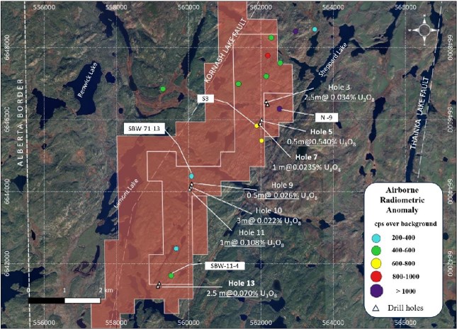
Figure 3. PNC Drill Holes from 1978
To view an enhanced version of this graphic, please visit:
https://images.newsfilecorp.com/files/9815/303310_d96ce95b04009b9c_006full.jpg
A summary of the 1978 PMC historic drill holes and significant assay intervals are identified in Table 2.
S3 Anomaly
Extensive brecciation and fracturing are evident in the area of this anomaly.
Radioactivity in the area reaches a maximum of 8,500cps. High radioactivity exists along the north-south trending structures. Two large radioactive zones, 50m by 250m and 50m by 150m in area, are present.
Historical drill hole 5 encountered pitchblende mineralization at a shallow depth of 30.2m. The assay average is 0.540% U3O8 over 0.5m. Drill hole 7 intersected 0.014% U3O8 over 0.5m at 20.5m depth.
These historical assay results highlight that mineralization encountered is not particularly continuous over any definite length and appears erratic, but the alteration system was intersected, is very extensive and is mainly argillic with minor propylitic.10
10 Assessment File Number: 74N13-NW-0011
N-9 Anomaly
Radioactivity greater than 500cps exists in an area 50m wide by 350m long, with a max of 15,000cps. Two trenches were dug in the area, where a maximum assay of 0.158% U3O8 was obtained. Four holes were also drilled, with the highest average assay obtained in drill hole 3 of 0.034% U3O8 over 2.5m at a depth of 17m and 0.024% U3O8 over 2m at a depth of 32m.11
BW 71-13 Anomaly
Two radioactive zones greater than 500cps were identified in this area, with both zones more than 100m long and 30m wide. Radioactivity is associated with north trending structures within pegmatites. In places within the zone radioactivity reaches a maximum of 15,000cps with a shield on the crystal.
Historical exploration saw eight trenches stripped and one trench blasted. The highest assays obtained are 0.26% U3O8 over 1m width on the west zone and 0.5% U3O8 over 1m with on the east zone.
Three holes were drilled. Drill hole 9 showed 0.026% U3O8 over 0.5m at a depth of 24.5m. In drill hole 10, assays were 0.022% U3O8 over 3m at a depth of 13m and drill hole 11 assays included 0.108% U3O8 over 1m at a depth of 8.8m.12
SBW 11-4 Anomaly
The geology in this area consists predominantly of pegmatitic feldspathic gneiss, feldspathic gneiss and biotite gneiss. The rocks in this area have been isoclinally folded and are cut off by a NS fault on the west side. Radioactivity greater than 500cps occurs 6m wide by 100m long.
One trench was blasted in the area of highest radioactivity, with the highest assay obtained being 0.078% U3O8 over 1m.
The drill hole No. 13 intersected radioactivity close to the fault zone at a depth of 57.5m, with the average assay obtained is 0.070% U3O8 over 2.5m.13
Similar Geological Setting to Beaver Lodge
The Project area was selected based on an analysis of what are believed to be similar style deposits, particularly around the Beaverlodge district. Eldorado Mining and Refining Ltd., that later merged with the Saskatchewan Mining Development Corporation to ultimately form Cameco, mined and milled the Beaverlodge site, producing a total of 56Mlb U3O8 at an average grade of 0.24% U3O8 from 17 uranium deposits between 1953 and 1982.14
This deposit style is noted as inter-granitic and shear zone vein systems, which are associated with significant faulting.
The SBW 71-13 anomaly, noted above, indicates a similar geological position to the significant Beaverlodge district orebodies, particularly the Ace, Fay and Verna mines (refer figure 4).
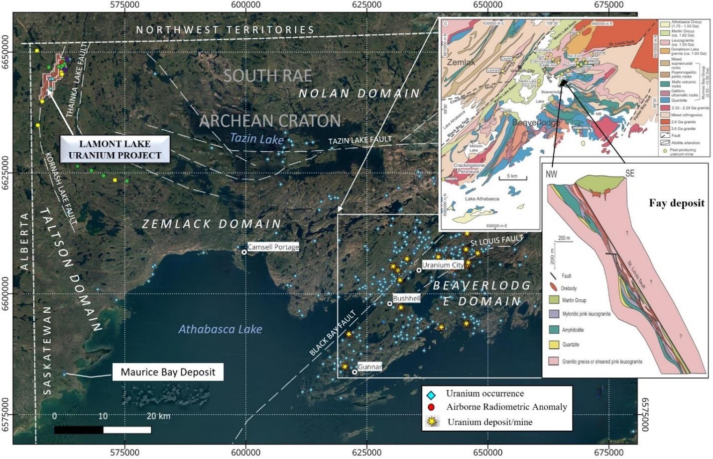
Figure 4. Geologic Map of the Ace-Fay-Verna Deposits (S.Dieng et al, 2013)
To view an enhanced version of this graphic, please visit:
https://images.newsfilecorp.com/files/9815/303310_d96ce95b04009b9c_007full.jpg
| Hole Id | East | North | Rl | Depth | Dip | Azimuth |
| 1 | 562,144 | 6,646,496 | 350 | 50.3 | -45 | 295 |
| 2 | 562,144 | 6,646,496 | 350 | 47.3 | -90 | 0 |
| 3 | 562,144 | 6,646,496 | 350 | 50.3 | -45 | 115 |
| 4 | 562,180 | 6,646,412 | 350 | 50.3 | -45 | 295 |
| 5 | 562,021 | 6,645,989 | 350 | 50.3 | -45 | 305 |
| 6 | 562,021 | 6,645,989 | 350 | 50.3 | -45 | 275 |
| 7 | 561,978 | 6,645,891 | 350 | 50.9 | -45 | 305 |
| 8 | 561,978 | 6,645,891 | 350 | 50.9 | -45 | 275 |
| 9 | 560,084 | 6,644,215 | 350 | 81.4 | -45 | 115 |
| 10 | 560,059 | 6,644,131 | 350 | 80.9 | -45 | 115 |
| 11 | 560,030 | 6,644,062 | 350 | 81.4 | -45 | 115 |
| 12 | 559,186 | 6,641,453 | 350 | 81.4 | -45 | 295 |
| 13 | 559,151 | 6,641,369 | 350 | 81.4 | -45 | 295 |
Table 1 PNC 1978 Drill Collars Derived from Maps
| Hole Id | Depth From | Depth To | Interval | U3O8 |
| (m) | (m) | (m) | (%) | |
| 1 | – | – | – | – |
| 2 | – | – | – | – |
| 3 | 22.1 | 24.1 | 2 | 0.021 |
| 4 | 13.4 | 14.4 | 1 | 0.0475 |
| 17 | 19 | 2 | 0.0298 | |
| 32 | 34.5 | 2.5 | 0.04 | |
| 5 | 30 | 30.5 | 0.5 | 0.54 |
| 6 | 47.5 | 50 | 2.5 | 0.0496 |
| 7 | 20.5 | 21 | 0.5 | 0.014 |
| 8 | 16 | 16.5 | 0.5 | 0.013 |
| 18 | 19 | 1 | 0.0245 | |
| 20 | 22 | 2 | 0.011 | |
| 9 | 24 | 25 | 1 | 0.0195 |
| 10 | 8.5 | 9 | 0.5 | 0.016 |
| 13..0 | 14 | 1 | 0.0285 | |
| 16 | 18 | 2 | 0.1975 | |
| 30 | 32 | 2 | 0.0165 | |
| 61.5 | 62.5 | 1 | 0.028 | |
| 11 | 8.8 | 9.8 | 1 | 0.108 |
| 12 | – | – | – | – |
| 13 | 57.5 | 60 | 2.5 | 0.0704 |
Table 2 PNC assay intervals
11 Assessment File Number: 74N13-NW-0011
12 Assessment File Number: 74N13-NW-0011
13 Assessment File Number: 74N13-NW-0011
14 Chi, G., Ashton, K., Deng, T., Xu, D., Li, Z., Song, H., Liang, L., & Kennicott, J. (2020). Comparison of granite-related uranium deposits in the Beaverlodge district (Canada) and South China – A common control of mineralization by coupled shallow and deep-seated geologic processes in an extensional setting [Review of Comparison of granite-related uranium deposits in the Beaverlodge district (Canada) and South China – A common control of mineralization by coupled shallow and deep-seated geologic processes in an extensional setting]. Ore Geology Reviews, 117(10339), 1-17; https://www.beaverlodgesites.com/.
In general, the geology present in the Project area contains similar characteristics of a Beaverlodge analogue.
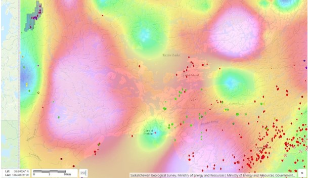
Figure 5. Tenements with Bougier Gravity vertical derivative overlay
To view an enhanced version of this graphic, please visit:
https://images.newsfilecorp.com/files/9815/303310_d96ce95b04009b9c_008full.jpg
Geological Overview
Most of the original Permit 4 area, which also covers the Project area, has been geologically mapped by the Department of Mineral Resources, Province of Saskatchewan, and published:15
- Report No. 6l, The Geology of the Thainka Lake Area West Half Saskatchewan by F. Koster, l96l
- Report No. 7l, The Geology of the Thainka Lake Area West Half Saskatchewan by F. Koster, l962
Bedrock outcrops over 30% of the area, and due to significant glaciation, thin deposits of gravel and sand cover much of the remainder.
The area lies in the Churchill Province of the Canadian Shield. It consists of a northeastern basement complex, red gneiss complex, pegmatite-migmatite complex, metasedimentary and metavolcanic complex and granodiorite complex.
The northeastern basement complex has three units: granitic component, quartz dioritic, and amphibolite. The red gneiss complex is subdivided into eastern conglomerate, red gneisses, granulite, and amphibolitic metasedimentary rocks. The pegmatite-migmatite complex consists of various sedimentary rocks, biotite and chlorite schists, and biotite-sericite-quartz schists and is intruded by various phases of the granodiorite complex.16
Regional faulting significantly influences the geological structure, as shown in Figure 6, particularly the arcuate Tazin River Fault, which is the most dominant and is a key geological division in the area. East of this fault lies a widespread area of red gneisses, apparently unconformably overlying a “granitic” basement. To the west of the Tazin River Fault lies the granodiorite complex. A pegmatite-migmatite complex, where the Project area mainly sits, is situated between the Tazin River Fault and the granodiorites.17
15 Assessment File Number: 74N12-0006
16 Assessment File Number: 74N13-NW-0011
Regional Geology
The red gneiss complex, east of the Tazin River Fault, consists of dark red gneiss, ranging in textural composition from rhyolitic to granitic. The red gneiss-pegmatite complex and pegmatite-biotite complex occur west of the Tazin River Fault. The feldspathic biotite gneiss is composed predominantly of biotite, quartz and feldspar. Feldspathic gneiss within the complex consists predominantly of quartz and feldspar. The pegmatitic portion of the feldspathic gneiss consists mainly of megacrysts of quartz, feldspar, minor biotite and chlorite. The pegmatitic portions appear in a majority of cases in noses of folds. In places, the pegmatite bodies cut across foliation; these characteristic features indicate that migmatisation took place early in the history of the rocks and were subsequently metamorphosed and folded with sediments and volcanics.
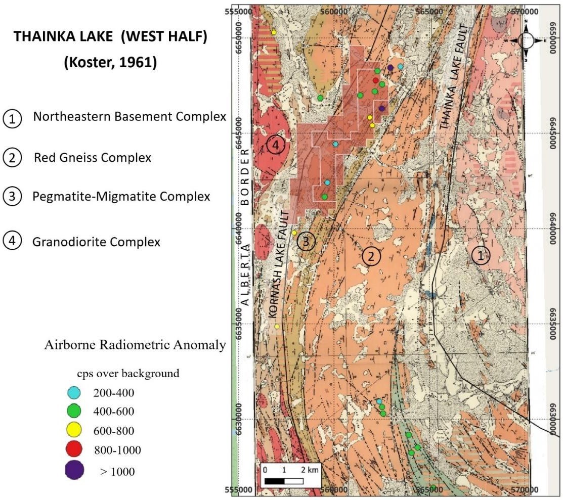
Figure 6. Regional Geology
To view an enhanced version of this graphic, please visit:
https://images.newsfilecorp.com/files/9815/303310_d96ce95b04009b9c_011full.jpg
17 Assessment File Number: 74N12-0006
Strong isoclinal folding has taken place in the Project area. Numerous shear zones or shear planes occur parallel to the limbs of the folds and sometimes cut across the hinges of folds. The shear planes are parallel to the gneissosity.
The area appears to have undergone a minimum of two periods of deformation:
-
Strong isoclinal folding exists, with fold axes trending N25°E and dipping vertically. The fold axes plunge between 10 and 40 degrees; and
-
East-west faulting (N115°E) which is almost perpendicular to the N25°E deformation. In place, especially in S3 anomaly area, movement along N25°E faults after east-west faulting has been observed.18
Next Steps
While the Lamont Lake Uranium Project is relatively unexplored from a modern perspective, there are objective indications of its Uranium potential based on the Company’s review of historical exploration data. The Project’s geology and structural setting suggest similarities with nearby significant mineralization and uranium production.
Previously identified mineralization is relatively shallow with minimal ground cover, indicating that future exploration efforts could be conducted at relatively lower costs when compared to the deeper mineralization situated in the Athabasca Basin.
The Company will continue to review historical data associated with the Project, which will be used to plan near-term exploration initiatives. As plans are finalized and exploration activities commence, additional updates will be provided to the market.
About Dark Star Minerals Inc.
The Company’s strategic focus is on advancing uranium exploration assets located in stable, established mining jurisdictions, with an emphasis on Canada’s premier uranium-bearing regions. This approach reflects the Company’s commitment to operating in jurisdictions with established regulatory frameworks, clear permitting processes, and a long history of responsible uranium exploration and development.
As part of this strategy, the Company has outlined a focused, phased exploration work program designed to advance priority uranium targets at the Ghost Lake Uranium Project, with a planned exploration budget of approximately C$300,000, subject to final program design and funding.
On April 15, 2026, the Company completed a Condition 2 (C2) extension of the Ghost Lake mineral claims pursuant to the mineral tenure regulations of Newfoundland and Labrador, maintaining the claims in good standing and allowing continued exploration activities while assessment work requirements are satisfied in accordance with provincial guidelines.
In addition, the Company confirms that it has extended its Bleasdell Lake uranium claims in Saskatchewan, with tenure now secured through April 17, 2027, providing continued claim validity while the Company evaluates and advances exploration plans on the property.
At Ghost Lake, the planned exploration program will emphasize surface-based geological verification of previously identified radiometric anomalies and prospective lithological contacts. Work will include detailed geological mapping and prospecting across multiple priority target areas, with particular attention paid to zones exhibiting elevated radiometric and gamma-ray responses interpreted from historic datasets and more recent surveys. These areas are interpreted to be associated with lithological contacts, structural features, and rhyolitic and volcanoclastic units.
Field activities will incorporate hand-held scintillometer surveys to refine the distribution and intensity of radiometric responses on the ground. Where warranted, selective hand trenching may be undertaken to improve bedrock exposure and evaluate subsurface continuity of anomalous zones. Channel sampling will be conducted across trenched and naturally exposed bedrock to support geochemical assessment and assist in defining priority follow-up targets.
The Ghost Lake program is designed to evaluate three principal target areas:
-
The southwest portion of the property, where elevated radiometric responses are associated with interpreted contacts and rhyolitic units;
-
A north-central area, centered on the contact between volcanic and volcanoclastic rocks; and
-
A south-central area, where radiometric anomalies may represent extensions of prospective lithologies identified elsewhere on the property.
Results from the planned exploration work will be used to refine geological interpretations, prioritize targets, define drill targets and guide subsequent exploration activities.
Qualified Person
Jeremy Hanson, P. Geo, an independent Consulting Geologist and a Qualified Person as defined under National Instrument 43-101, has reviewed and approved the disclosure in this news release for consistency with NI 43-101 reporting requirements.
About Dark Star Minerals Inc.
Dark Star Minerals Inc. is a mineral exploration company focused on the strategic acquisition and advancement of uranium and critical mineral resources. The Company holds an option to acquire a 100% interest in the Ghost Lake claims located in the prolific CMB of Newfoundland and Labrador, comprising 28,575 ha of contiguous claim blocks, and owns the Bleasdell Project spanning over 515 ha in Northern Saskatchewan, Canada.
For further information please contact:
Marc Branson
President, CEO and Director
E‐mail: investors@darkstarminerals.com
Telephone: 604‐816‐2555
Forward‐Looking Statements:
his news release includes certain “forward-looking statements” under applicable Canadian securities legislation. Forward-looking statements involve risks, uncertainties, and other factors that could cause actual results, performance or developments to differ materially from those expressed or implied by such statements. Forward-looking statements in this news release include, but are not limited to, statements relating to planned exploration programs, budgets, the timing and completion of the Consolidation, and the Company’s future exploration and financing activities. Although the Company believes the expectations reflected in the forward-looking information are reasonable, there can be no assurance that such expectations will prove to be correct. Readers are cautioned not to place undue reliance on forward-looking statements. Except where required by law, the Company disclaims any intention or obligation to update or revise any forward-looking statement, whether as a result of new information, future events, or otherwise.
Neither the CSE nor its Regulation Services Provider (as that term is defined in the policies of the CSE) accepts responsibility for the adequacy or accuracy of this release.


