


Toronto, Ontario–(Newsfile Corp. – March 18, 2026) – Montero Mining and Exploration Ltd. (TSXV: MON) (OTC Pink: MXTRF) (FSE: ES0) (“Montero” or the “Company“) is pleased to provide an update on the interpretation of geological, geochemical and geophysical datasets at its Elvira gold project in Chile’s Maricunga Gold Belt, following completion of the Phase 1 exploration program previously reported on March 2, 2026.
The integrated analysis confirms the presence of a district-scale high-sulphidation hydrothermal system at Elvira and has identified several structurally controlled alteration centres, resistivity domains and sulphide-bearing chargeability anomalies that represent priority areas for follow-up exploration and potential drill testing.
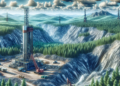
The Project comprises a contiguous package of mining concessions covering the interpreted alteration footprint and structural corridors identified to date. A location map showing the regional setting is presented in Figure 1 and a detailed concession outline with simplified geology is presented in Figure 2, with geological mapping and alteration shown in Figures 3 and 4, and geophysical datasets presented in Figures 5, 6 and 7.
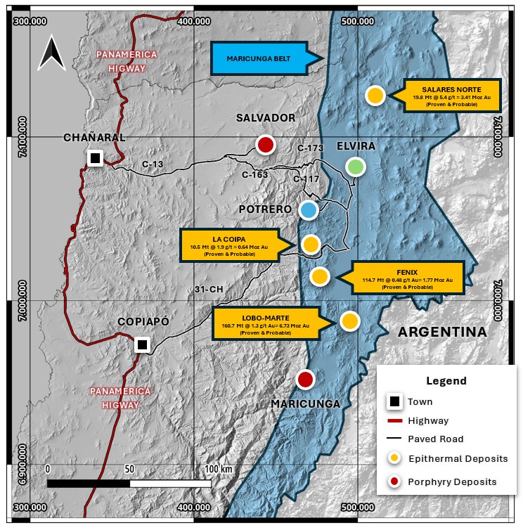
Figure 1: Regional location map of the Elvira Project, Maricunga Belt, Chile.
To view an enhanced version of this graphic, please visit:
https://images.newsfilecorp.com/files/11789/288984_a37deece54ae8ac9_003full.jpg
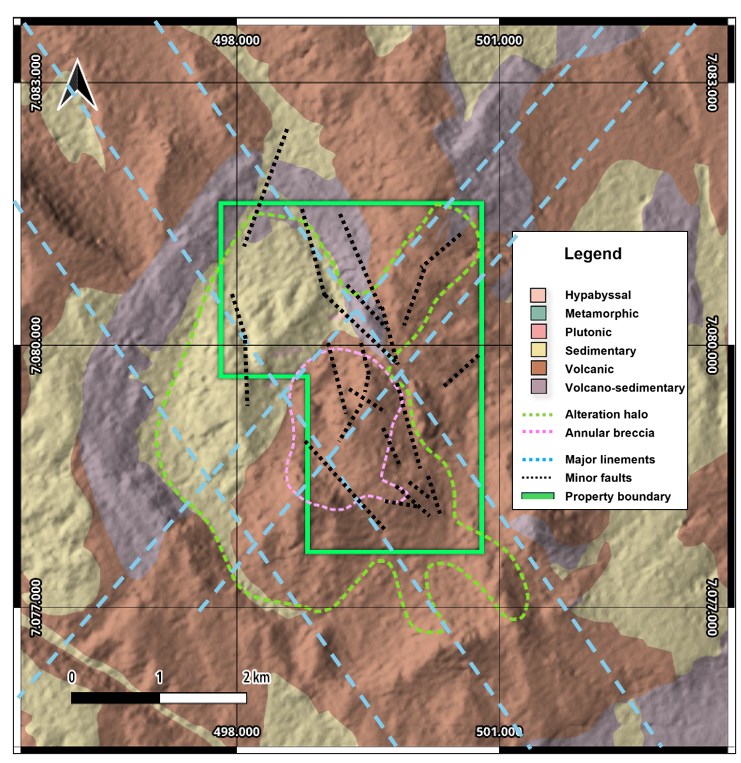
Figure 2: Elvira Project concession boundary and simplified geological map.
To view an enhanced version of this graphic, please visit:
https://images.newsfilecorp.com/files/11789/288984_a37deece54ae8ac9_004full.jpg
Dr. Tony Harwood, President and CEO of Montero, commented: “The integration of geological mapping, geochemistry and geophysical datasets has significantly improved our understanding of the Elvira system. Results indicate a large high-sulphidation epithermal system developed within volcanic-sedimentary host rocks intruded by dacitic porphyry and an andesitic dome complex, with mineralization controls linked to a major structural corridor and associated silicified alteration zones. These findings allow us to prioritize specific areas for potential drill testing as we advance the project.”
Key Interpretation Results
The interpretation of the combined exploration datasets indicates:
- A large hydrothermal alteration system developed within volcanic-sedimentary host rocks consistent with a high-sulphidation epithermal system extending across several kilometres.
- Multiple north-northwest to north-northeast trending structural corridors interpreted from magnetic data and geological mapping that may represent fluid pathways and potential feeder structures.
- Strong correlation between alteration zones, geochemical anomalies and geophysical responses, suggesting a coherent mineralizing system.
- Chargeability and resistivity contrasts identified in Induced Polarization (“IP“) surveys consistent with zones of hydrothermal alteration and possible sulphide mineralization at depth.
- A central deep-rooted conductive structure flanked by two resistive domains interpreted as silicified zones associated with hydrothermal alteration.
These features collectively support the interpretation that Elvira hosts a significant hydrothermal system with the potential for preserved mineralization.
Geological Interpretation
Detailed geological mapping confirms that the Elvira system developed within Miocene volcanic-sedimentary sequences comprising lithic tuffs, volcanic agglomerates, and sandstones intruded by dacitic porphyry to the west and an andesitic dome complex to the east (Figure 3).
The system is characterized by extensive advanced argillic alteration, including quartz-alunite alteration, vuggy silica bodies and hydrothermal breccias mapped across the central portion of the project (Figure 4).
These alteration assemblages, together with the presence of silicified breccias, vuggy silica veins and quartz-alunite alteration, are characteristic of high-sulphidation epithermal systems throughout the Maricunga Belt and commonly occur above deeper porphyry-style mineralization systems, providing further support for the interpreted scale and fertility of the Elvira hydrothermal system.
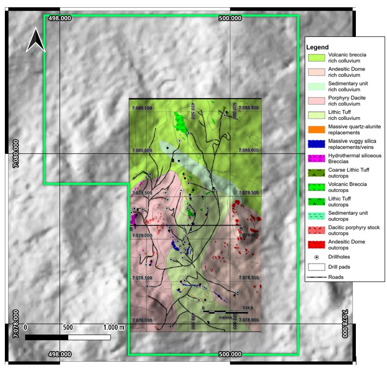
Figure 3: Geological map of the Elvira Project showing volcanic-sedimentary host rocks intruded by dacite porphyry to the west and an andesite dome complex to the east. The high-sulfidation epithermal system is characterized by quartz-alunite alteration, vuggy silica veins and hydrothermal breccias developed within the volcanic-sedimentary units (Frutos, 2025).
To view an enhanced version of this graphic, please visit:
https://images.newsfilecorp.com/files/11789/288984_a37deece54ae8ac9_008full.jpg
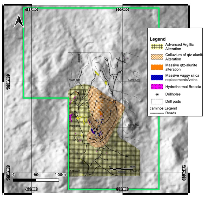
Figure 4: Alteration map derived from geological mapping showing the distribution of quartz-alunite alteration and advanced argillic assemblages developed across the volcanic-sedimentary host rocks and intrusive bodies. The central alteration zone hosts the widest vuggy silica replacement bodies and represents the most prospective zone within the hydrothermal system for mineralization. (Frutos, 2025).
To view an enhanced version of this graphic, please visit:
https://images.newsfilecorp.com/files/11789/288984_a37deece54ae8ac9_007full.jpg
In addition, high-resolution multi-element geochemical datasets are currently being evaluated using porphyry vector modelling techniques to assess potential geochemical gradients that may indicate proximity to a deeper porphyry-style mineralizing source beneath the epithermal system.
Field mapping has identified two priority exploration areas within the central alteration system:
- Western Target – associated with hydrothermal breccia bodies developed along the western margin of the alteration system and extending for more than 800 metres.
- Eastern Target – located within volcanic-sedimentary host rocks where vuggy silica veins are thickest and most abundant, representing a potential stratigraphically controlled replacement zone.
The scale and intensity of alteration observed at Elvira suggest a robust hydrothermal system capable of hosting mineralization.
Geophysical Interpretation
Ground magnetic and IP surveys have improved the understanding of subsurface structures and lithological contrasts across the property. The ground magnetic survey covered approximately 205 kilometres of survey lines spaced at 50 metres, while IP surveys were completed along seven lines totalling approximately 19.2 kilometres.
Magnetic Highlights
Magnetic data highlight several linear structural trends and intrusive contacts that may represent potential conduits for mineralizing fluids. Magnetic vector inversion modelling identifies a large magnetic anomaly interpreted as an andesitic dome complex with magnetic susceptibilities ranging from approximately 0.01 to 0.07 SI units, consistent with magnetite-bearing volcanic lithologies (Figure 5).
A narrow magnetic low truncating the western margin of the dome is interpreted as a deep-rooted structural corridor, which coincides with a conductive feature identified in the IP survey. This structural corridor forms the core of the interpreted priority exploration corridor and is spatially associated with coincident chargeability anomalies identified in the IP dataset.
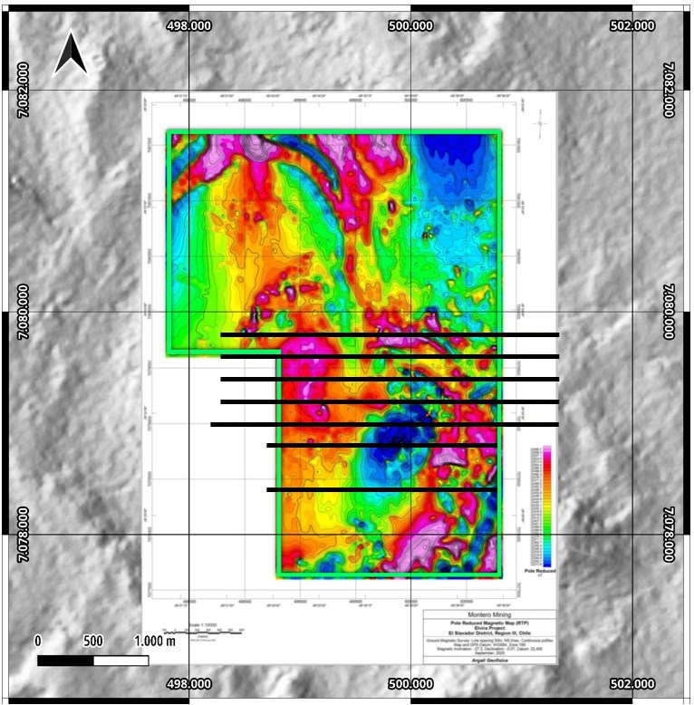
Figure 5: Elvira Project showing the Pole Reduced Magnetic Intensity Grid (line spacing 50 m) and location seven IP lines survey lines (pole-dipole, a=100 m, n=1 to 20) (Argali, 2026).
To view an enhanced version of this graphic, please visit:
https://images.newsfilecorp.com/files/11789/288984_a37deece54ae8ac9_009full.jpg
IP-Resistivity Highlights
IP-resistivity data identified zones of contrasting chargeability and resistivity that coincide with mapped alteration zones and structural features (Figure 6). These anomalies are interpreted as potential targets for further evaluation.
A consistent geophysical pattern is observed across multiple IP lines consisting of:
- A western resistive lobe interpreted as silicified rock associated with hydrothermal alteration.
- A central conductive zone interpreted as a fault or structural corridor.
- An eastern resistive lobe associated with silicification near the andesitic dome complex.
Strong chargeability anomalies reaching up to approximately 25 mV/V occur along the central structural corridor and beneath the western resistive lobe, suggesting the presence of sulphide mineralization at depth (Figures 6 and 7) however, these responses are geophysical in nature and require validation through drilling.
The coincidence of strong chargeability anomalies with silicified resistive zones, mapped hydrothermal breccias, and the interpreted structural corridor represents a compelling integrated exploration target that will be further refined through ongoing geochemical vector modelling and three-dimensional geological interpretation.
The interpreted structural corridor and associated resistive alteration zones define a prospective exploration corridor approximately 700 metres by 600 metres in extent. Geophysical responses are interpretive in nature and do not necessarily indicate the presence of economic mineralization or mineral resources.
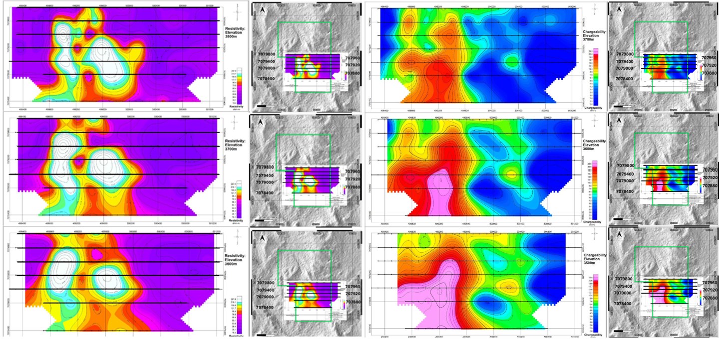
Figure 6: Plan map of Inverted Resistivity (left) and Chargeability (right) anomalies at elevations 3800 m (top), 3700 m, 3600 m derived from the 2025 IP survey. Elevated chargeability values reflect zones of increased sulphide content within the hydrothermal system. A strong chargeability anomaly is centred between IP lines 7078800N and 7079200N and coincides with mapped alteration and structural corridors identified from geological mapping and magnetic interpretation (Argali, 2026).
To view an enhanced version of this graphic, please visit:
https://images.newsfilecorp.com/files/11789/288984_a37deece54ae8ac9_011full.jpg
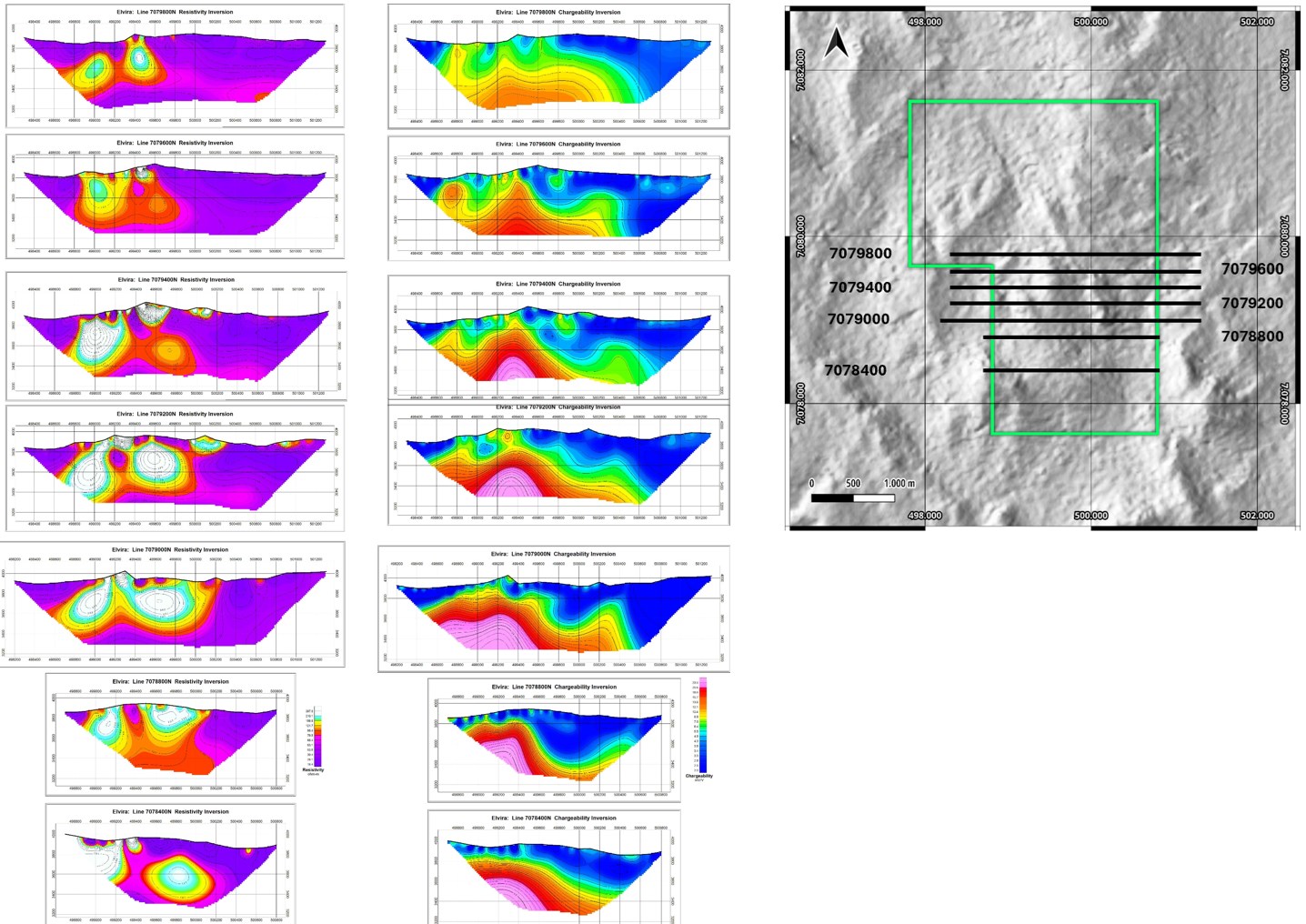
Figure 7: Representative IP Resistivity and Chargeability inversion sections across the Elvira hydrothermal system showing resistive silicified zones flanking a central conductive structural corridor interpreted as a major fault or structural feeder zone. Chargeability anomalies associated with sulphide mineralization occur beneath the western resistive lobe and along the central structural corridor (Argali, 2026).
To view an enhanced version of this graphic, please visit:
https://images.newsfilecorp.com/files/11789/288984_a37deece54ae8ac9_013full.jpg
Integrated Targeting
The Company is currently integrating all available geological, geochemical and geophysical datasets using integrated structural interpretation and three-dimensional geophysical inversion modelling, together with data-driven analytical techniques including artificial intelligence-assisted modelling.
This initial work has resulted in the identification of several priority exploration areas within the broader alteration system that warrant further investigation.
High-resolution multi-element analytical geochemical results generated from the recent surface sampling program are currently undergoing geochemical vector analysis and will be integrated with the geological and geophysical datasets to further refine the evolving three-dimensional exploration model. Results from the geochemical vector analysis will be incorporated into the Company’s broader integrated interpretation workflow as part of ongoing three-dimensional geological modelling.
In particular, the intersection of the central structural corridor with the western resistive silicified zone and strong shallow chargeability anomalies represents a high-priority exploration target for potential drill testing. The interpretation process remains ongoing and will be refined as additional analytical work and data integration, artificial intelligence assisted modelling, and independent technical review is completed.
Next Steps
The next phase of work at Elvira will focus on:
- Finalizing the integrated geological model.
- Continued interpretation of geochemical and geophysical datasets.
- Completion of the ongoing geochemical vectoring analysis of the high-resolution multi-element dataset.
- Advancing technical evaluation of priority exploration targets toward potential drill testing.
- Prioritizing potential drill targets.
- Completing technical evaluation prior to any decision regarding drill testing.
The Company expects to provide further updates as interpretation of the integrated datasets progresses.
Qualified Person
The scientific and technical information contained in this press release has been reviewed and approved by Mr. Marcial Vergara, B.Sc., and Mr. Mike Evans, M.Sc. Pr.Sci.Nat., each a Qualified Person as defined by National Instrument 43-101 – Standards of Disclosure for Mineral Projects, and consulting geologists to the Company.
About Montero
Montero Mining and Exploration Ltd. is a Canadian exploration company focused on gold and copper exploration in Chile. Montero holds a 100% interest in the Avispa copper-molybdenum project in the Palaeocene Porphyry Cu-Mo Belt of northern Chile and has an option to acquire the Elvira and Potrero gold projects in the Maricunga Gold Belt. These projects are currently being advanced through exploration. The Company’s board and management have a proven track record in discovery and development of precious and base metal projects.
Montero is listed on the TSX Venture Exchange under the symbol MON and has 8,353,833 Common Shares and 835,383 stock options outstanding.
For more information, contact:
Montero Mining and Exploration Ltd.
Dr. Tony Harwood, President, and Chief Executive Officer
E-mail: ir@monteromining.com
Tel: +1 604 428 7050
www.monteromining.com
Neither TSX Venture Exchange nor its Regulation Services Provider (as that term is defined in the policies of the TSX Venture Exchange) accepts responsibility for the adequacy or accuracy of this release.
CAUTIONARY STATEMENT REGARDING FORWARD-LOOKING INFORMATION: This news release includes certain “forward-looking information” within the meaning of applicable Canadian securities laws. Forward-looking information in this press release includes, but is not limited to, statements regarding: the integration and interpretation of geological, geochemical and geophysical data; the application of artificial intelligence and machine learning tools; the identification, evaluation or prioritization of areas for further exploration; the potential for mineralization; and the timing or scope of future exploration activities, including any potential drilling. Generally, forward-looking information can be identified by the use of forward-looking terminology such as “plans”, “expects”, “does not expect”, “is expected”, “budget”, “scheduled”, “estimates”, “forecasts”, “intends”, “anticipates”, “does not anticipate”, or “believes”, or variations of such words and phrases, or statements that certain actions, events or results “may”, “could”, “would”, “might” or “will” occur or be achieved. Such information is based on information currently available to Montero and on assumptions management believes are reasonable as of the date of this news release. Forward-looking information is subject to known and unknown risks, uncertainties and other factors that may cause actual results, level of activity, performance or achievements of the Company to be materially different from those expressed or implied by such forward-looking information. These risks and uncertainties include, but are not limited to: risks related to mineral exploration and development activities; uncertainties inherent in the interpretation of geological and geophysical data; the speculative nature of mineral exploration; commodity price fluctuations; changes in general market conditions; regulatory approvals and permitting risks; availability of financing; operational and technical risks; and other risk factors described in the Company’s public disclosure documents filed on SEDAR+. There can be no assurance that such forward-looking information will prove to be accurate, as actual results and future events could differ materially from those anticipated in such statements. Readers are cautioned not to place undue reliance on forward-looking information. Montero does not undertake to update any forward-looking information, except in accordance with applicable securities laws.


