


Toronto, Ontario–(Newsfile Corp. – March 26, 2026) – Montero Mining and Exploration Ltd. (TSXV: MON) (OTC Pink: MXTRF) (FSE: ES0) (“Montero” or the “Company“) is pleased to report the results of independent geochemical vector modelling completed by Fathom Geophysics (“Fathom“) on rock geochemistry collected from its Elvira gold project in Chile’s Maricunga Gold Belt.
The modelling forms part of the Company’s ongoing integrated exploration program, following previously reported geological mapping, geophysical surveys, and target definition work, and combining these datasets with surface geochemistry and artificial intelligence-assisted modelling to refine exploration targets within the Elvira hydrothermal system.
The results identify two coincident and spatially related deep porphyry-style targets beneath the central alteration system, further supporting the interpretation that Elvira hosts a large high-sulphidation epithermal system potentially related to a deeper porphyry mineralizing centre. A regional location map of the project and a detailed map of the project area are shown in Figures 1 and 2.
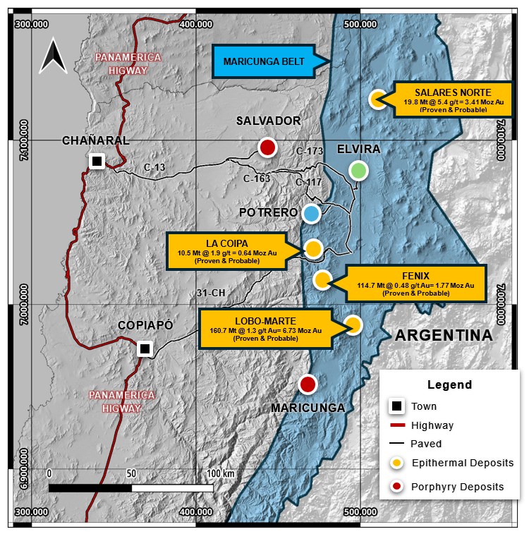
Figure 1: Regional location map of the Elvira Project, Maricunga Belt, Chile*.
To view an enhanced version of this graphic, please visit:
https://images.newsfilecorp.com/files/11789/290078_0d1e657bb4d5d858_001full.jpg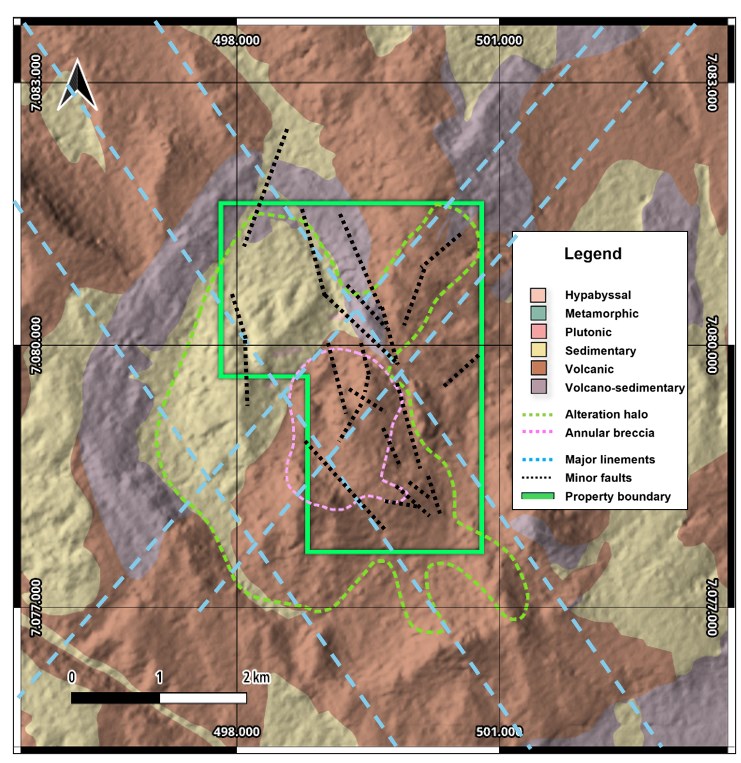
Figure 2: Elvira Project concession boundary and simplified geological map.
To view an enhanced version of this graphic, please visit:
https://images.newsfilecorp.com/files/11789/290078_0d1e657bb4d5d858_002full.jpg
*Adjacent property Mineral Resource and Mineral Reserve estimates shown in Figure 1, including those for Salares Norte, Fenix Gold, La Coipa and Lobo-Marte, are derived from publicly available disclosures prepared by the respective owners in accordance with applicable securities regulations, including: Gold Fields Limited, Salares Norte Technical Report Summary (effective 31 December 2024); Rio2 Limited, NI 43-101 Feasibility Study Technical Report for the Fenix Gold Project (effective 16 October 2023); and Kinross Gold Corporation, La Coipa and Lobo-Marte Mines Mineral Reserve and Resource Statement as at 31 December 2024, prepared in accordance with CIM Definition Standards. Such information is not necessarily indicative of mineralization on the Company’s Elvira project.
Dr. Tony Harwood, President and CEO of Montero, commented: “Independent geochemical footprint modelling has defined coherent porphyry-style targets beneath Elvira. Integrated with our geological, geophysical, and surface epithermal data, these results support the interpretation of a large vertically zoned mineralized system at depth. We are now applying artificial intelligence-assisted modelling to refine and prioritize drill targets.”
Geochemical Context
The geochemical vector modelling is based on a dataset of thirty-eight (38) rock samples collected from the Elvira project and analyzed using four-acid digestion ICP-MS methods to provide high-sensitivity multi-element geochemistry suitable for porphyry footprint analysis.
Geochemical results from recent surface sampling, as previously reported by the Company, confirm the potential for a large high-sulphidation hydrothermal system at Elvira, characterized by widespread arsenic enrichment and localized molybdenum anomalism. These patterns are consistent with vertically zoned porphyry-epithermal systems and provide key inputs to the geochemical vector modelling. Geochemical sample locations are shown in Figure 3.
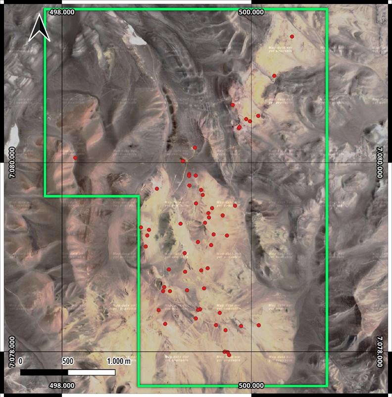
Figure 3: Location map for the area showing distribution of surface rock samples shown as red dots. The grid that is overlain has 1.5 km spacing for northings and 1.5 km spacing for eastings.
To view an enhanced version of this graphic, please visit:
https://images.newsfilecorp.com/files/11789/290078_0d1e657bb4d5d858_005full.jpg
Geochemical Vector Modelling and Target Definition
The Company commissioned Fathom to conduct three-dimensional porphyry footprint modelling using multi-element rock geochemistry collected during recent exploration programs.
The modelling utilized the 38 rock samples analysed by four-acid digestion ICP-MS, providing high-sensitivity multi-element data for key pathfinder elements including As, Bi, Cu, Li, Mo, Sb, Se, Sn, Te, Tl, and W. These samples represent a subset of a broader geochemical dataset collected across the project area.
The modelling focused on these eleven (11) key pathfinder elements, which were incorporated into the modelling workflow to evaluate the spatial distribution of multi-element geochemistry relative to idealized porphyry zonation models within a three-dimensional grid of the project area.
Two industry-recognized geochemical zonation models were applied:
- Cohen (2011) porphyry footprint model.
- Halley et al. (2015) porphyry alteration and geochemical dispersion model.
Both models generated high-confidence porphyry targets beneath the central Elvira alteration system, defining a coherent target zone at depth.
Model Results and Target Definition
The results define a coherent porphyry-style target zone at depth, comprising two spatially related modelled targets (Figures 4 and 5), coincident with previously identified alteration zones, structural corridors, and geophysical anomalies.
EL-FG-01C – Cohen Model Target
This target occurs beneath the central portion of the geochemical sampling area and represents a high-confidence porphyry footprint anomaly. The highest scoring part of the target occurs approximately 1.5 km below surface, with lower-scoring extensions extending to shallower depths.
The combined plan and cross-sectional views (Figure 4) illustrate a laterally continuous and vertically extensive anomaly interpreted to represent a potential porphyry-style centre at depth.
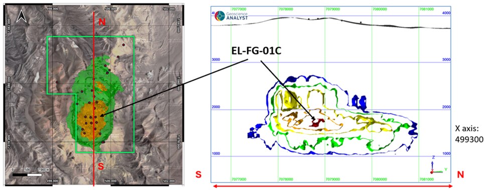
Figure 4: Combined plan and cross-sectional views of the Cohen (2011) porphyry footprint modelling results based on multi-element rock geochemistry.
To view an enhanced version of this graphic, please visit:
https://images.newsfilecorp.com/files/11789/290078_0d1e657bb4d5d858_007full.jpg
EL-FG-01H – Halley Model Target
A second target generated using the Halley model occurs slightly east of the current sampling area.
This target is somewhat deeper than the Cohen model target but also displays a strong model fit and is interpreted to represent the same underlying mineralized system.
The combined plan and cross-sectional views (Figure 5) indicate a coherent and deeper-seated anomaly that is spatially related to the Cohen model target.
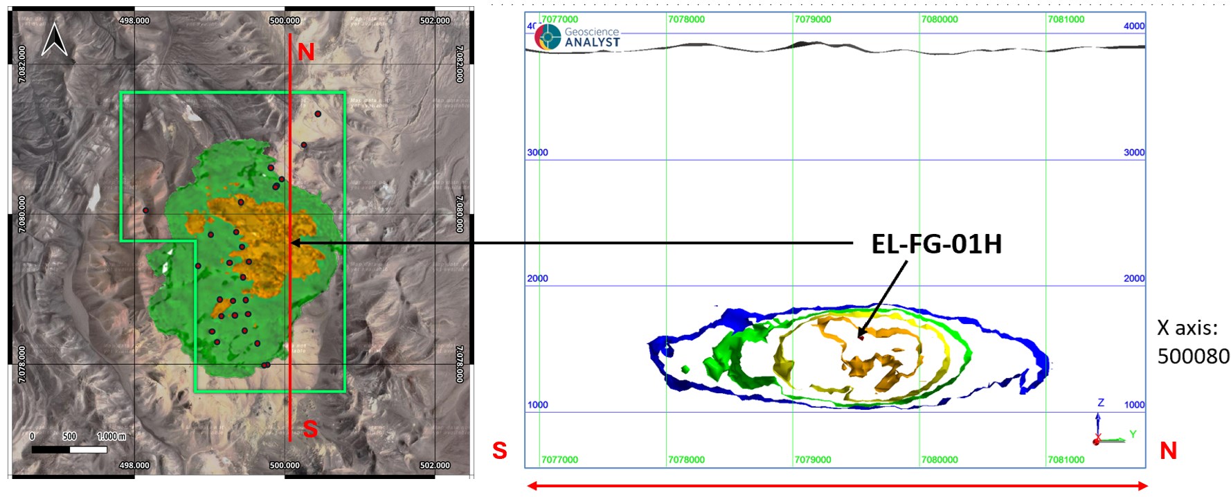
Figure 5: Combined plan and cross-sectional views of the Halley et al. (2015) porphyry footprint modelling results based on multi-element rock geochemistry.
To view an enhanced version of this graphic, please visit:
https://images.newsfilecorp.com/files/11789/290078_0d1e657bb4d5d858_009full.jpg
These results illustrate a consistent geochemical response at depth and support the interpretation of a spatially related porphyry target zone.
The current modelling is based on a relatively limited number of samples with constrained spatial distribution. As such, the geometry and separation of modelled targets may reflect data coverage. Additional geochemical sampling, particularly to the east and along open anomalous trends, is expected to further refine and potentially consolidate the interpreted target zones.
Interpretation
The spatial coincidence of the Cohen and Halley model outputs defines a coherent porphyry-style target zone beneath the central alteration system. These results establish a consistent geochemical vector toward a potential porphyry centre at depth, building on previously reported geological, geophysical, and geochemical interpretations, and represent priority targets for follow-up exploration and drill testing.
Next Steps
The Company will continue integrating geological, geochemical and geophysical datasets using structural interpretation and artificial intelligence-assisted modelling.
Upcoming exploration work will focus on:
- Extending surface geochemical sampling to better constrain the geochemical footprint.
- Continued integration of geological and geophysical datasets.
- Refinement of three-dimensional exploration models.
- Prioritization of potential drill targets.
The Company expects to provide further updates as interpretation of the integrated datasets progresses.
Qualified Person
The scientific and technical information contained in this press release has been reviewed and approved by Mr. Marcial Vergara, B.Sc., and Mr. Mike Evans, M.Sc. Pr.Sci.Nat., each a Qualified Person as defined by National Instrument 43-101 – Standards of Disclosure for Mineral Projects, and independent consulting geologists to the Company.
About Montero
Montero Mining and Exploration Ltd. is a Canadian exploration company focused on gold and copper exploration in Chile. Montero holds a 100% interest in the Avispa copper-molybdenum project in the Palaeocene Porphyry Cu-Mo Belt of northern Chile and has an option to acquire the Elvira and Potrero gold projects in the Maricunga Gold Belt. These projects are currently being advanced through exploration. The Company’s board and management have experience in the discovery and development of precious and base metal projects.
Montero is listed on the TSX Venture Exchange under the symbol MON and has 8,353,833 Common Shares and 835,383 stock options outstanding.
For more information, contact:
Montero Mining and Exploration Ltd.
Dr. Tony Harwood, President, and Chief Executive Officer
E-mail: ir@monteromining.com
Tel: +1 604 428 7050
www.monteromining.com
Neither TSX Venture Exchange nor its Regulation Services Provider (as that term is defined in the policies of the TSX Venture Exchange) accepts responsibility for the adequacy or accuracy of this release.
CAUTIONARY STATEMENT REGARDING FORWARD-LOOKING INFORMATION: This news release includes certain “forward-looking information” within the meaning of applicable Canadian securities laws. Forward-looking information in this press release includes, but is not limited to, statements regarding: the integration and interpretation of geological, geochemical and geophysical data; the application of artificial intelligence and machine learning tools; the identification, evaluation or prioritization of areas for further exploration; the potential for mineralization; and the timing or scope of future exploration activities, including any potential drilling. Generally, forward-looking information can be identified by the use of forward-looking terminology such as “plans”, “expects”, “does not expect”, “is expected”, “budget”, “scheduled”, “estimates”, “forecasts”, “intends”, “anticipates”, “does not anticipate”, or “believes”, or variations of such words and phrases, or statements that certain actions, events or results “may”, “could”, “would”, “might” or “will” occur or be achieved. Such information is based on information currently available to Montero and on assumptions management believes are reasonable as of the date of this news release. Forward-looking information is subject to known and unknown risks, uncertainties and other factors that may cause actual results, level of activity, performance or achievements of the Company to be materially different from those expressed or implied by such forward-looking information. These risks and uncertainties include, but are not limited to: risks related to mineral exploration and development activities; uncertainties inherent in the interpretation of geological and geophysical data; the speculative nature of mineral exploration; commodity price fluctuations; changes in general market conditions; regulatory approvals and permitting risks; availability of financing; operational and technical risks; and other risk factors described in the Company’s public disclosure documents filed on SEDAR+. There can be no assurance that such forward-looking information will prove to be accurate, as actual results and future events could differ materially from those anticipated in such statements. Readers are cautioned not to place undue reliance on forward-looking information. Montero does not undertake to update any forward-looking information, except in accordance with applicable securities laws.


