


Vancouver, British Columbia–(Newsfile Corp. – March 26, 2026) – Casa Minerals Inc. (TSXV: CASA) (OTCQB: CASXF) (FSE: 0CM) (the “Company” or “Casa”) is pleased to announce that it has received a large dataset of historic drill hole information from the Congress Gold Mine Project in Yavapai County, Arizona, USA. Comprehensive desktop technical studies integrating this data with the Company’s own 2022 drilling campaign have resulted in the identification and delineation of three distinct priority exploration zones that will form the basis of the 2026 field and drilling program.
HIGHLIGHTS
- Receipt of a large historic drill hole database greatly expanding the geological model for the Congress Gold Mine Project
- 3D modelling of over 100 historic and recent drill holes confirms strong structural integrity and continuity of the gold-bearing vein systems
- Three distinct exploration zones classified: Echo Bay Exploration Zone (~750m x 1,000m), Malartic Exploration Zone (~450m x 1,150m), and New Congress Niagara Exploration Zone (~800m x 1,000m)
- Echo Bay Exploration Zone designated highest priority target based on historic drill density and potential for expanded mineralization envelope
- Historic drill intercepts include highlights such as 1.2m @ 43.88 g/t Au, 2.0m @ 21.88 g/t Au, 3.3m @ 27.13 g/t Au, and 11.4m @ 4.81 g/t Au within the Echo Bay Zone
- Congress Gold Mine Project is fully permitted with excellent road access and proximity to an experienced regional labor force
- Company geologists and field personnel are being mobilized for initial site preparation and drill program setup
HISTORIC DRILL DATABASE COMPILATION
Casa Minerals is pleased to announce the receipt of a comprehensive dataset of historic drill hole collars, surveys, and assay records from the Congress Gold Mine Project. This data was compiled from exploration programs conducted by previous operators — most notably Echo Bay Mines Ltd. — during the 1980s through the early 1990s. The database encompasses a significant number of drill holes distributed across the project area, substantially expanding the known geological framework of the property.
Historic exploration at the Congress Gold Mine was conducted during a period when gold market conditions were materially lower than today’s environment, which directly influenced the selection criteria and cut-off grades used by previous operators. Consequently, the historic programs focused predominantly on higher-grade gold intersections, and many lower-grade vein intercepts that may be economically significant at current gold prices were not assigned the same level of analytical priority. Casa believes this creates a meaningful opportunity to reinterpret the mineralization system with a lower economic threshold, logically expanding the dimensions of the mineralization envelope that will be targeted in the forthcoming drilling season.
Important Disclosure: The historic drill hole results referenced in this news release were collected and reported by previous operators under practices that predate current NI 43-101 standards. These results are disclosed solely for contextual and geological interpretation purposes. They have not been verified by a current Qualified Person, do not conform to NI 43-101, and are not classified as current mineral resources or mineral reserves. A Qualified Person has not done sufficient work to classify the historic results as current mineral resources or mineral reserves, and Casa is not treating them as such.
THREE-DIMENSIONAL MODELLING AND VEIN SYSTEM VALIDATION
Desktop technical studies have included rigorous 3D modelling of all available drill hole data using industry-standard geological modelling software. The resulting three-dimensional representation of the drill hole database, illustrated in Figure A below, demonstrates the remarkable density of historic drill coverage across the project and confirms the structural coherence and continuity of the principal gold-bearing vein systems.
The 3D model was constructed using NAD83 / UTM Zone 12N coordinates and captures drill holes ranging from surface to depths approaching 600 metres below ground elevation. The model reveals that:
- The dominant vein systems exhibit strong northeast-southwest structural orientation, consistent with the principal fault architecture identified on surface
- The alignment and attitude of vein structures intercepted in the Company’s 2022 confirmatory drilling campaign correlate with high fidelity to those projected from the historic drill hole database, validating the overall geological model
- The 2022 drilling campaign identified additional vein structures not captured in the historic database, indicating that the current geological model is likely incomplete and that the total mineralized footprint may be materially larger than previously understood
- Incorporating lower-grade vein intercepts — previously deprioritized by historic operators under lower gold price conditions — into the mineralization envelope substantially increases the aggregate target volume for future drilling
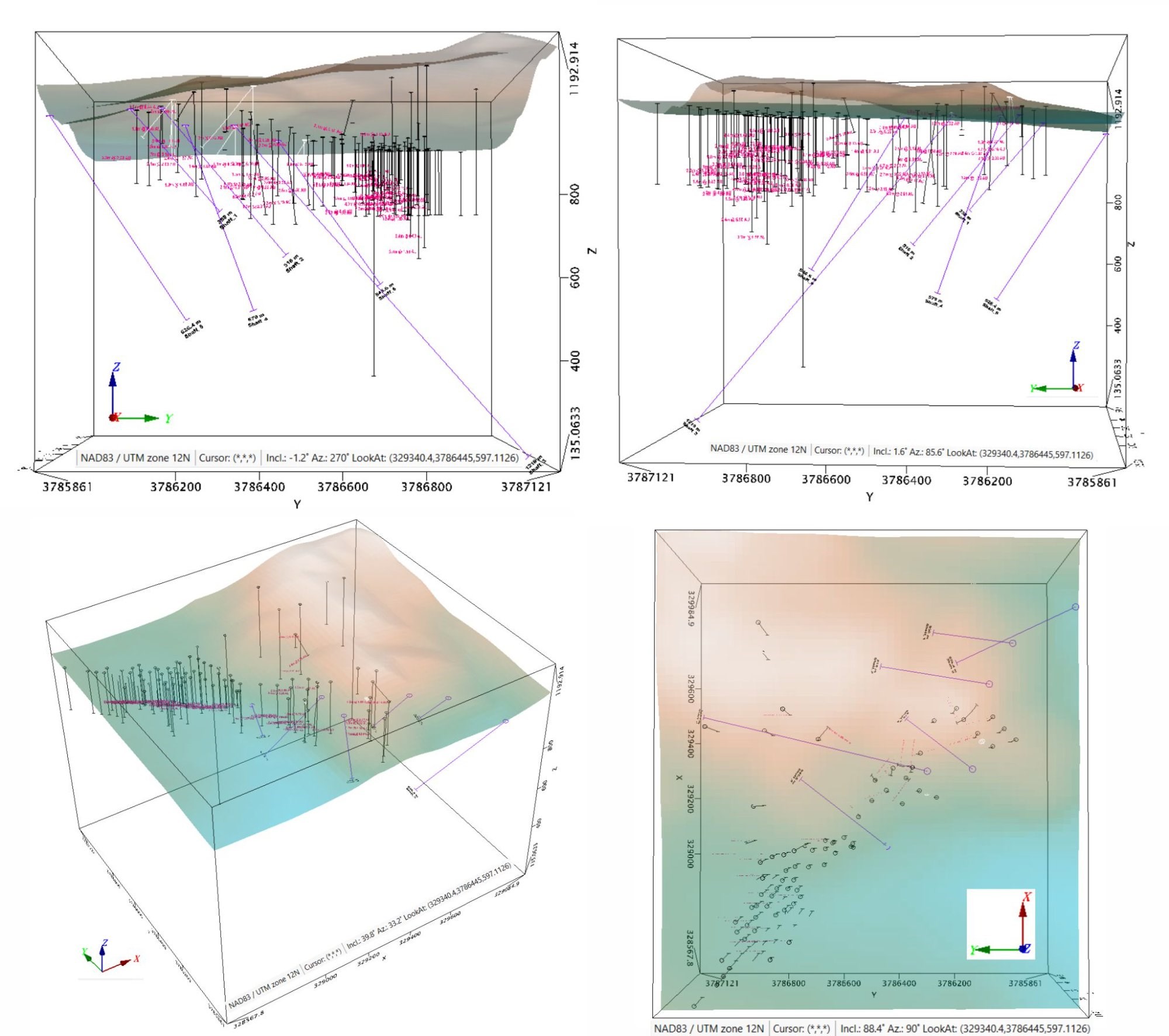
Figure A: Four-panel 3D presentation of historic and recent drill hole collars and traces, Congress Gold Mine Project. Views from west (upper left), east (upper right), oblique (lower left), and plan (lower right). Coordinate system: NAD83 / UTM Zone 12N. The high density of drill traces illustrates the extensive historic exploration coverage across the project area. Pink/magenta traces represent historic drill holes; black traces represent more recent drilling. Purple lines denote projected vein orientations.
To view an enhanced version of this graphic, please visit:
https://images.newsfilecorp.com/files/1750/290037_3e63fd76341e7b14_001full.jpg
THREE PRIORITY EXPLORATION ZONES — 2026 PROGRAM BASIS
Detailed integration of the historic drill database with geological mapping, vein system mapping conducted in 2022, and structural interpretation has enabled Casa to formally classify three distinct priority exploration zones within the Congress Gold Mine Project. The classification of each zone reflects the combination of historic drill density, vein system geometry, and the nature of the gold mineralization documented to date. Figures 1 through 4 present these zones in their regional and local contexts.
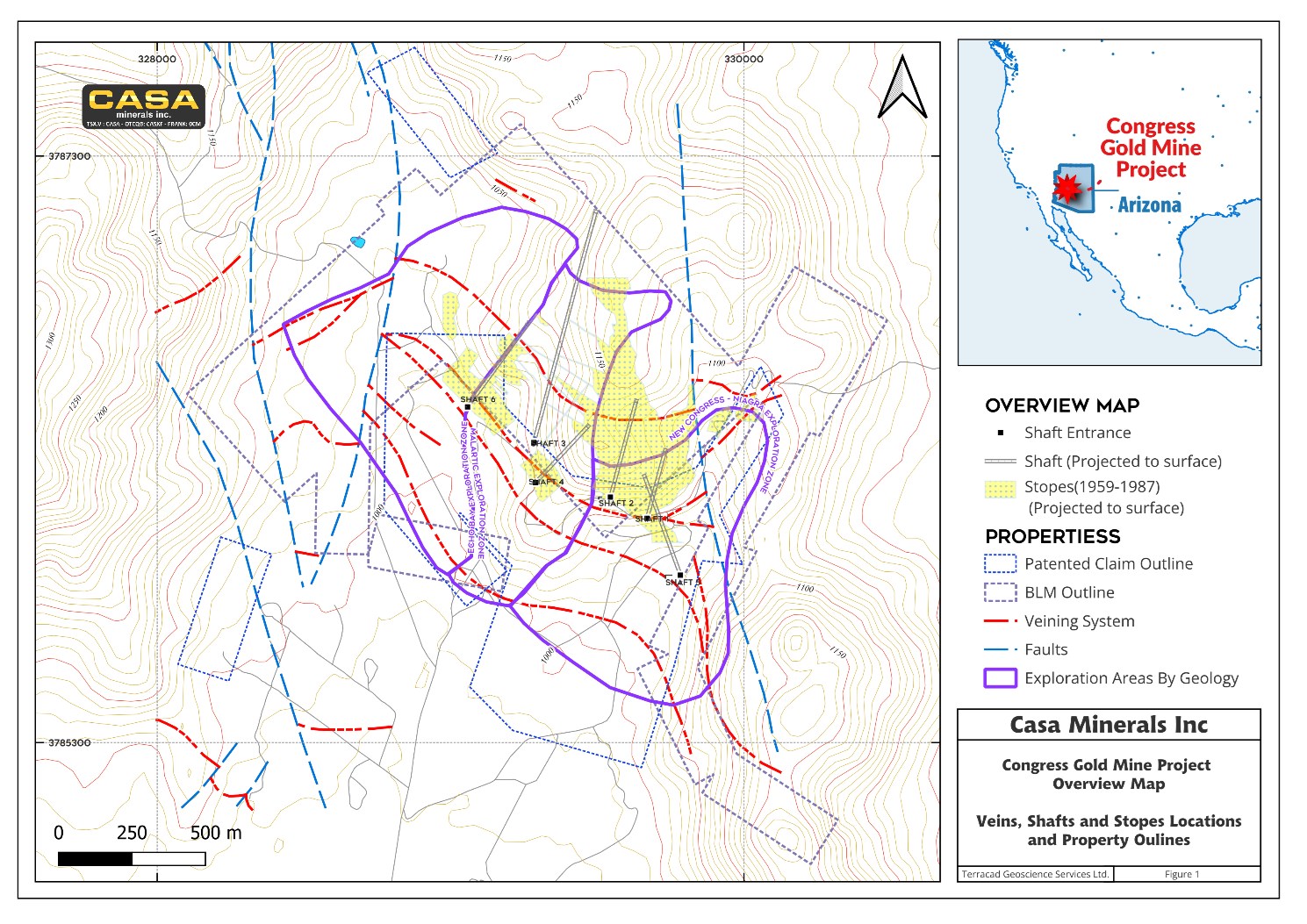
Figure 1: Regional overview map of the Congress Gold Mine Project showing principal vein systems (red dashed), fault corridors (blue dashed), shaft locations (Shafts 1 through 6), historic stope outlines (yellow, 1959-1987), patented claim and BLM claim outlines, and the location of the three principal exploration zones. The project is situated in Yavapai County, Arizona.
To view an enhanced version of this graphic, please visit:
https://images.newsfilecorp.com/files/1750/290037_3e63fd76341e7b14_002full.jpg
Echo Bay Exploration Zone — Highest Priority Target
The Echo Bay Exploration Zone, measuring approximately 750 metres by 1,000 metres, is the largest and most intensively drilled zone on the property. It encompasses the historic non-NI 43-101 resource outline that was previously defined by Echo Bay Mines and represents the core of the historic gold-producing system at Congress. The zone is bounded by the principal northeast-trending veining corridors and is cut by northwest-trending fault structures that locally displace but do not terminate the mineralized vein arrays.
As illustrated in Figure 2, the Echo Bay Exploration Zone hosts a dense cluster of historic drill hole intercepts distributed across the full extent of the zone. The drill hole collars and assay intercepts depicted in the figure provide compelling evidence for broad, zone-scale gold mineralization. Notably, the higher-grade intercepts are concentrated along the principal vein corridors while lower-grade disseminated and stockwork gold is documented in the intervening ground. This spatial distribution is characteristic of orogenic gold systems and is consistent with the geological setting at Congress.
Selected historic drill intercepts within the Echo Bay Exploration Zone include:
- 1.2m @ 43.88 g/t Au — exceptional high-grade intercept within the principal vein corridor
- 3.3m @ 27.13 g/t Au — high-grade intercept demonstrating vein width and continuity
- 2.0m @ 21.88 g/t Au — high-grade vein intercept in the central portion of the zone
- 2.4m @ 19.03 g/t Au — confirming strong grade continuity along strike
- 11.4m @ 4.81 g/t Au — broad, elevated-grade intercept indicative of wide mineralization envelopes within the vein system
- 1.5m @ 15.28 g/t Au — demonstrating high-grade vein core and broader lower-grade haloes
- 2.0m @ 12.19 g/t Au and 7.3m @ 11.00 g/t Au — further confirming grade and continuity of the principal vein arrays
- 3.1m @ 11.19 g/t Au and 2.0m @ 15.63 g/t Au — documented in the southwestern portion of the zone, indicating lateral continuity
Given the historic drill density, the documented grade profile, and the alignment of the 2022 confirmatory drilling with the historic vein model, the Echo Bay Exploration Zone has been assigned the highest exploration priority for the 2026 program. The Company views the zone as offering the clearest near-term pathway to NI 43-101 resource delineation.
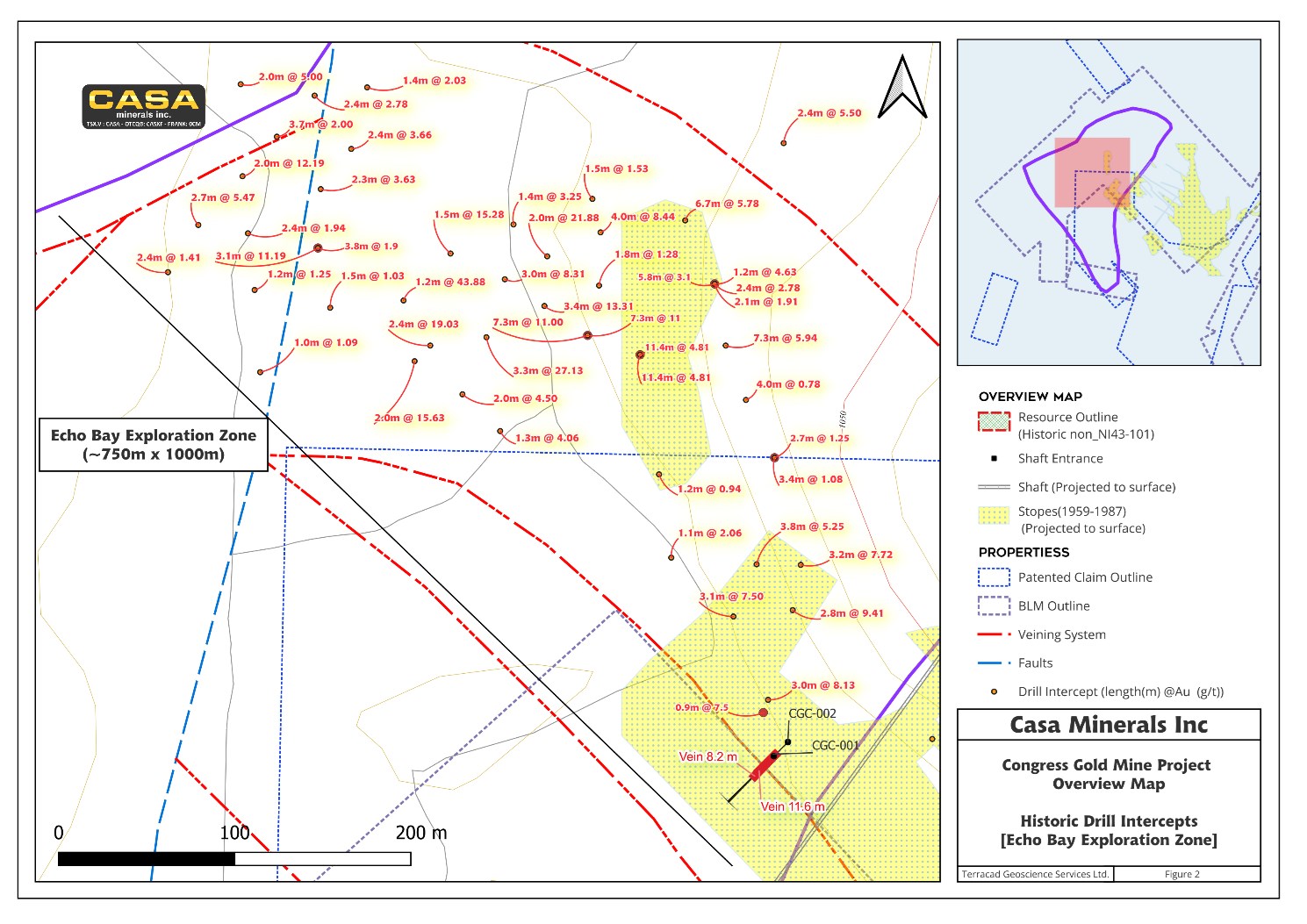
Figure 2: Detailed plan map of the Echo Bay Exploration Zone (~750m x 1,000m), Congress Gold Mine Project. Shown are historic drill hole intercepts (brown dots annotated with interval length in metres and gold grade in g/t), principal vein system traces (red dashed), fault corridors (blue dashed), historic stope outlines (yellow), shaft locations, and the historic non-NI 43-101 resource outline (red hatch). Selected intercepts include 1.2m @ 43.88 g/t Au, 3.3m @ 27.13 g/t Au, 11.4m @ 4.81 g/t Au, and 2.4m @ 19.03 g/t Au, among numerous others.
To view an enhanced version of this graphic, please visit:
https://images.newsfilecorp.com/files/1750/290037_3e63fd76341e7b14_003full.jpg
Malartic Exploration Zone
The Malartic Exploration Zone covers an area of approximately 450 metres by 1,150 metres and is situated to the south and southeast of the Echo Bay Exploration Zone. The zone is named after the “Malartic-style” stratabound and vein-hosted gold mineralization that has been documented in this area of the project. Historic shaft locations CGC-003 and CGC-004 are located within this zone, providing direct underground access for potential future development.
The Malartic Exploration Zone is characterized by multiple subparallel northwest-striking vein sets that have been intercepted in a series of shallow to moderate-depth drill holes. The vein system includes documented vein widths of 27 feet, 38 feet, and 55 feet (as labelled on Figure 3), indicating substantial structural corridors capable of hosting economically significant gold mineralization.
Representative historic drill intercepts within the Malartic Exploration Zone include:
- 3.6m @ 0.74 g/t Au and 10.3m @ 1.73 g/t Au — broad lower-grade intercepts within the principal vein corridor demonstrating wide mineralization envelopes
- 10.36m @ 1.41 g/t Au and 8.1m @ 3.53 g/t Au — moderate-grade intercepts confirming continuity of the vein arrays
- 7.7 @ 3.56 g/t Au and 8.1m @ 2.53 g/t Au — further demonstrating consistent grade within vein-hosted mineralization
- 3.2m @ 7.72 g/t Au and 2.8m @ 9.41 g/t Au — higher-grade intercepts at the northern margin of the zone (shared boundary with the Echo Bay Zone)
The Malartic Exploration Zone is relatively underexplored compared to the Echo Bay Zone, and the relatively sparse drill coverage suggests significant upside potential for zone expansion with systematic drilling.
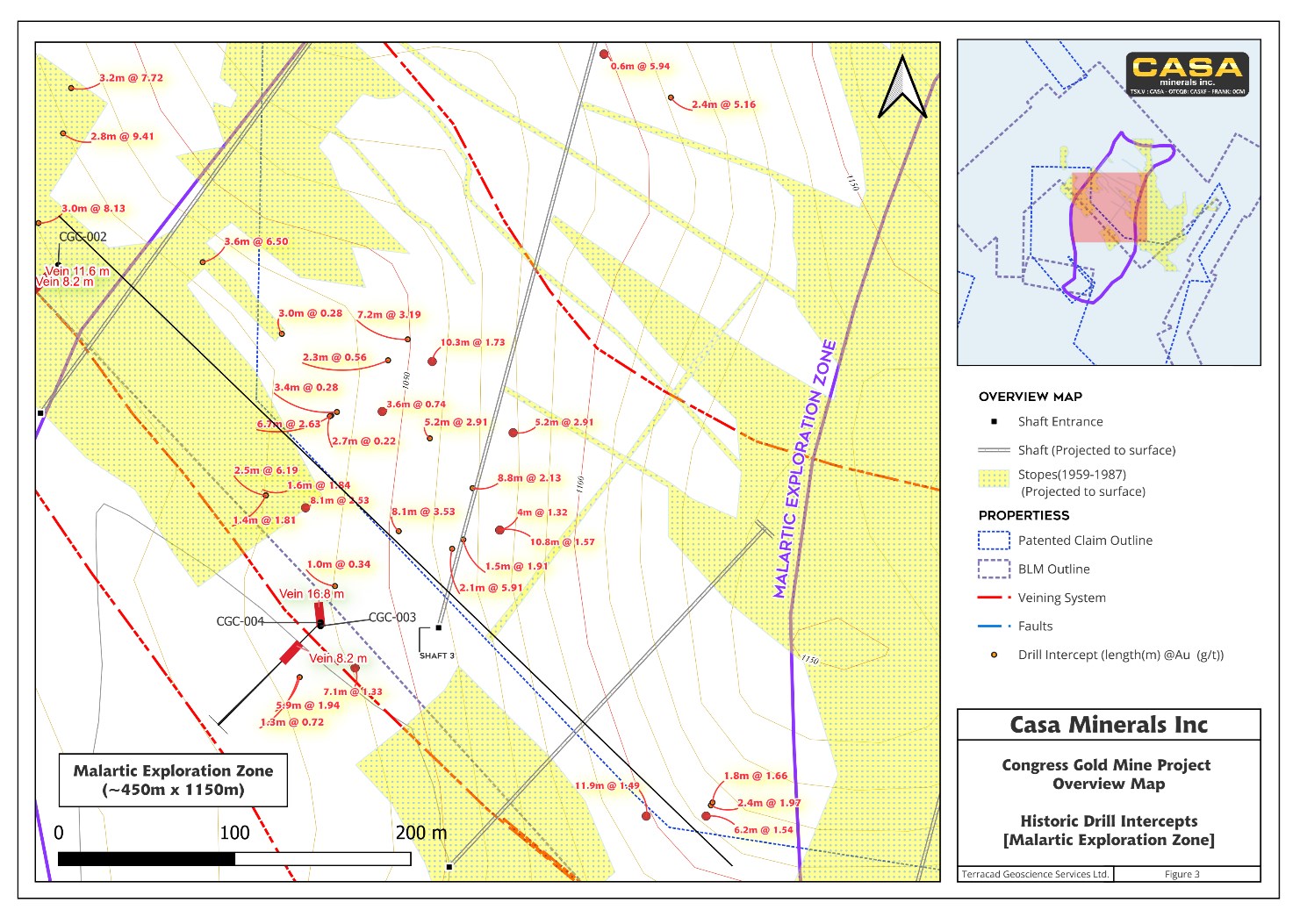
Figure 3: Detailed plan map of the Malartic Exploration Zone (~450m x 1,150m), Congress Gold Mine Project. Shown are historic drill hole intercepts (annotated with gold values), principal vein system traces, shaft locations including CGC-003 and CGC-004, historic stope outlines, and documented vein widths of 8.2m, 11.6m, and 16.8m.
To view an enhanced version of this graphic, please visit:
https://images.newsfilecorp.com/files/1750/290037_3e63fd76341e7b14_004full.jpg
New Congress Niagara Exploration Zone
The New Congress Niagara Exploration Zone, measuring approximately 800 metres by 1,000 metres, is the northernmost of the three classified exploration zones and is situated along a structurally distinct corridor characterized by the northwest-striking New Congress-Niagara fault system. This zone encompasses historic Shaft 1 as well as drill holes CGC-008, CGC-009, and CGC-010 from the Company’s 2022 exploration program.
The 2022 drilling in this zone identified four discrete veins with widths ranging from 49.5 feet to 206 feet — a notably wide structural corridor. These widths are illustrated in Figure 4 as Vein 49.5 ft, Vein 55 ft, Vein 70.5 ft, and Vein 206 ft. The scale of these structural features highlights the potential for significant bulk-tonnage style mineralization within this zone, distinct from the higher-grade but narrower veins documented in the Echo Bay Zone.
Critically, the 2022 drilling at the New Congress Niagara Zone identified several vein structures that are not represented in the historic drill database, reinforcing the Company’s view that the existing geological model incompletely captures the full scope of the vein system. This structural incompleteness, combined with the relatively limited historic drill coverage of this zone, underscores its exploration potential.
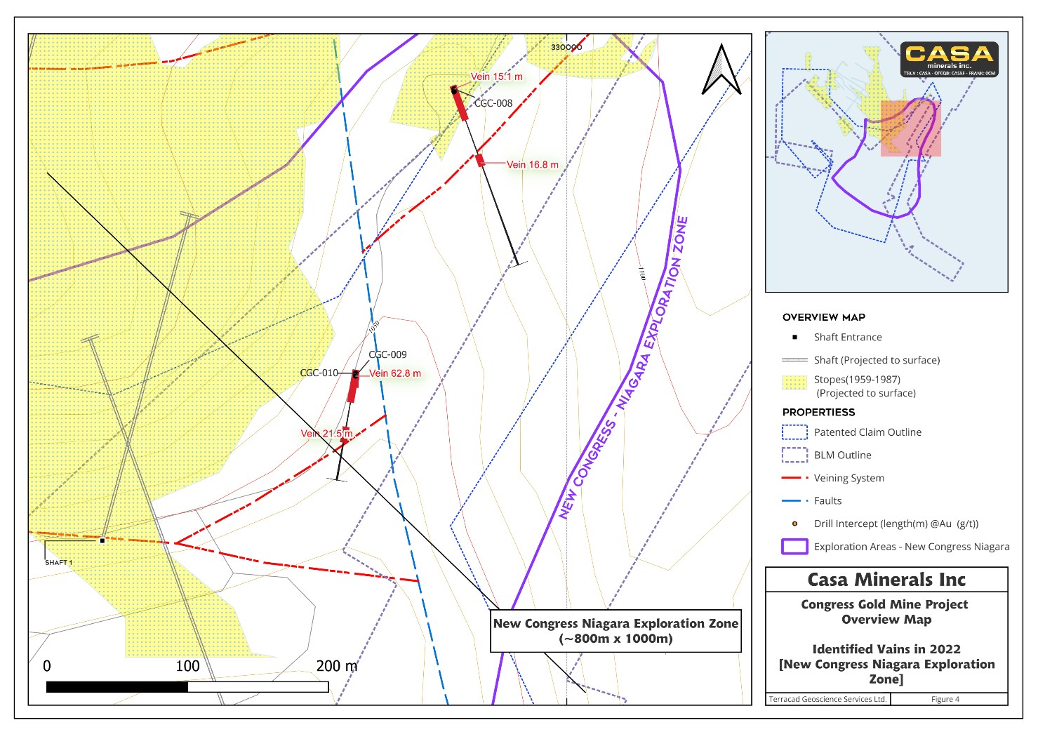
Figure 4: Detailed plan map of the New Congress Niagara Exploration Zone (~800m x 1,000m), Congress Gold Mine Project. Shown are drill hole locations from the 2022 exploration program (CGC-008, CGC-009, CGC-010) alongside Shaft 1, with identified vein widths of 49.5 ft, 55 ft, 70.5 ft, and 206 ft. The purple outline denotes the exploration zone boundary.
To view an enhanced version of this graphic, please visit:
https://images.newsfilecorp.com/files/1750/290037_3e63fd76341e7b14_005full.jpg
PROJECT STATUS AND 2026 FIELD PROGRAM
The Congress Gold Mine Project is fully permitted for exploration and mining activities in Yavapai County, Arizona. The property benefits from:
- Fully permitted status: All necessary exploration and access permits are in place, enabling rapid mobilization of field crews and drilling equipment
- Excellent road access: Paved and maintained road access to the property boundary facilitates cost-effective equipment and supply logistics
- Experienced regional labor force: The Yavapai County region has a well-established mining and exploration workforce with proven experience in gold exploration projects of this type
- Infrastructure: Existing shaft infrastructure and historic workings provide geological reference points and potential future development opportunities
The Company is currently mobilizing a team of geologists and field personnel to the Congress Gold Mine Project for initial site preparation, geological review, and establishment of the field infrastructure required for the 2026 drilling program. Detailed drill program parameters, including planned hole locations, depths, and targeting rationale, will be provided in a subsequent technical news release.
MANAGEMENT COMMENTARY
“The receipt of this historic drill database is a genuinely significant development for Casa Minerals,” stated Farshad Shirvani, President and CEO. “For the first time, we now have a comprehensive view of the full scope of historic exploration at Congress, and what we see is highly encouraging. The 3D model clearly validates our 2022 findings and demonstrates that the gold system is both continuous and larger than historic estimates suggested. With gold trading at current levels, the lower-grade vein intercepts that were historically deprioritized now become compelling exploration targets in their own right. The Echo Bay Zone, with intercepts like 1.2m @ 43.88 g/t and 11.4m @ 4.81 g/t, gives us a very strong foundation from which to build a modern NI 43-101 resource. We are mobilizing our team and look forward to reporting our first drill results from the 2026 season.”
QUALIFIED PERSON
Mr. Erik Ostensoe, P.Geo., a Director and Chief Geologist of the Company, a Qualified Person as defined by National Instrument 43-101 – Standards of Disclosure for Mineral Projects, has reviewed and approved the scientific and technical disclosure in this news release.
ABOUT CASA MINERALS INC.
Casa Minerals Inc. is a mineral exploration company focused on gold, copper, and strategic minerals exploration in North America. The Company holds a 90% interest in the historic Congress Gold Mine in Arizona and is advancing multiple projects in British Columbia, including the Arsenault copper-gold-silver project. Casa’s experienced management team is committed to creating shareholder value through the discovery and development of economic mineral deposits. For more information, please visit: www.casaminerals.com
ON BEHALF OF THE BOARD OF DIRECTORS
Farshad Shirvani, M.Sc. Geology
President, CEO and Director
For more information, please contact:
Casa Minerals Inc.
Farshad Shirvani, President & CEO
Phone: (604) 678-9587
Email: contact@casaminerals.com
CAUTIONARY NOTE REGARDING FORWARD-LOOKING STATEMENTS
This news release contains “forward-looking information” within the meaning of applicable Canadian securities legislation. Forward-looking information includes, but is not limited to, statements regarding: the Company’s exploration plans and programs for 2026; anticipated drilling activities at the Congress Gold Mine Project; the classification and prioritization of exploration zones; expectations regarding resource definition and the potential to advance the project to NI 43-101 compliant standards; interpretations of historic drill data and 3D geological models; mineralization potential and domain expansion; and mobilization of field personnel. Forward-looking information is based on the opinions and estimates of management at the date the information is made and is subject to a variety of risks and uncertainties and other factors that could cause actual events or results to differ materially from those anticipated. Such factors include, without limitation: uncertainties regarding exploration results; risks related to the accuracy and completeness of historic data; the inability to verify historic assay results; variations in mineralization and grade; the speculative nature of mineral exploration; challenges in obtaining required permits and approvals; fluctuations in commodity prices; availability of financing; changes in economic and market conditions; environmental and regulatory risks; operating hazards; and other risks inherent in the mineral exploration industry. The Company does not undertake to update any forward-looking information, except in accordance with applicable securities laws.
NEITHER TSX VENTURE EXCHANGE NOR ITS REGULATION SERVICES PROVIDER (AS THAT TERM IS DEFINED IN THE POLICIES OF THE TSX VENTURE EXCHANGE) ACCEPTS RESPONSIBILITY FOR THE ADEQUACY OR ACCURACY OF THIS RELEASE.


