



Vancouver, British Columbia–(Newsfile Corp. – September 10, 2026) – Myriad Uranium Corp. (CSE: M) (OTCQB: MYRUF) (FSE: C3Q) (“Myriad” or the “Company“) is pleased to announce preliminary gamma probe equivalent uranium (eU3O8) results from drilling at Gem, one of six tightly-clustered historical uranium deposits at the Copper Mountain Uranium Project in central Wyoming (see Figure 1). Union Pacific and Southern California Edison had intended to mine the project by way of a large-scale conventional process commencing in 1983. These estimates are not chemical assays and remain subject to laboratory verification.
Highlights
-
Myriad’s CEO, Thomas Lamb, commented: “We are delighted with these results. Mineralisation at Gem is indeed near-surface and intervals so far are long with excellent grades. The longest mineralized interval is 34.90 metres (114.5 feet) at 210 ppm eU3O8 from 10.65 m in GEM0002DD, with grades of up to 1,368 ppm eU3O8.”
-
Myriad’s current Phase II drill program is designed to achieve two primary objectives:
-
Verify mineralization that underpins a historical resource estimate1 of 26.63 Mlbs eU3O8 and generate modern data to support a future maiden mineral resource estimate.
-
The Company believes that Copper Mountain has an Exploration Target2 of 1,111 to 2,971 Mt at 100 ppm eU3O8 or 222 to 594 Mt at 500 ppm eU3O8, and we want to evaluate this exploration upside by testing historical targets identified through drilling in the 1970s and assessing new targets generated by Myriad’s own exploration work. This target is described in detail here.
-
-
Myriad has now completed three drill holes at Gem for a total of 507 metres (1,663 feet) of drilling.
-
All three holes intersected multiple broad intervals of near-surface uranium mineralization.
-
Across the three holes, 21 mineralized intervals exceed 100 ppm eU3O8.
-
The longest mineralized interval is 34.90 metres (114.5 feet) at 210 ppm eU3O8 from 10.65 m in GEM0002DD.
-
The highest grade intercepted is 1,368 ppm eU3O8 in hole GEM0002DD.
Best Intervals Above 100 ppm eU₃O₈ Threshold
| Hole ID | From (m) | To (m) | Length (m) | eU3O8 (ppm) | eU3O8 (%) | Peak Grade (eU3O8 ppm) | Depth (m) |
| GEM0001DD | 14.37 | 31.14 | 16.76 | 166 | 0.017 | 471 | 23.1 |
| including | 21.23 | 24.73 | 3.51 | 285 | 0.028 | 471 | 23.1 |
| GEM0001DD | 43.17 | 72.59 | 29.41 | 295 | 0.030 | 647 | 45.8 |
| including | 48.05 | 56.13 | 8.08 | 326 | 0.033 | 541 | 52.7 |
| including | 57.50 | 67.71 | 10.21 | 365 | 0.037 | 528 | 61.7 |
| GEM0002DD | 10.65 | 45.55 | 34.90 | 210 | 0.021 | 1,368 | 16.1 |
| including | 15.83 | 17.05 | 1.22 | 1,027 | 0.103 | 1,368 | 16.1 |
| including | 22.69 | 25.59 | 2.90 | 301 | 0.030 | 636 | 23.8 |
| GEM0003DD | 22.66 | 55.89 | 33.22 | 235 | 0.024 | 603 | 28.4 |
| including | 23.42 | 26.47 | 3.05 | 274 | 0.027 | 493 | 25.9 |
| including | 27.23 | 38.82 | 11.58 | 308 | 0.031 | 603 | 28.4 |
| GEM0003DD | 60.30 | 70.36 | 10.06 | 161 | 0.016 | 360 | 64.8 |
- Equivalent uranium (eU3O8) grades are radiometric estimates derived from downhole gamma logging and are not chemical assays. They are preliminary, may be affected by disequilibrium, borehole diameter, casing, water, probe calibration and other borehole conditions, and will be verified by laboratory assay results. Verification will include standard QAQC protocols such as the insertion of blanks, standards (Certified Reference Materials) and duplicates as well as the implementation of chain of custody procedures.
- The intervals above are selected preliminary radiometric intervals reported above a 100 ppm eU3O8 threshold and are intended to highlight the most material intercepts by length, grade and grade-thickness. They should be read together with Appendix 1, which provides the full interval summaries at the stated reporting thresholds.
- Reported intervals are downhole lengths and do not represent true widths, which have not yet been determined.
The Gem Deposit
The Gem deposit is located approximately 1.6 km (1 mi) south of the main Canning deposit. Several thousand tons of uraniferous granite were reportedly excavated from the Gem Mine in the 1950’s by John Jay of Riverton, Wyoming, the original owner. None of the excavated material was milled, and stockpiles adjacent to the mine were reported to average 0.07% eU3O8 (the location has since been remediated by the BLM).
RMEC’s activities in the area began in 1973 and consisted of various geophysical and geochemical surveys, surface mapping, and a limited programme of hammer and core drilling. Work in 1979 consisted of the completion of detailed surface mapping and evaluation of the area’s potential as a bulk sampling site. Additional drilling defined a resource area which at the time had potential to be a full-scale production pit. Initial resource estimates showed approximately 3.07 million tons of mineralised granite containing 1.44 million pounds eU3O8 at an average grade of 0.023% eU3O8 in the Inferred and Indicated categories using a 100 ppm cut-off (Southard et. al., 1979). A Qualified Person has not done sufficient work to classify the historical estimate as current mineral resources or mineral reserves, and Myriad is not treating the historical estimate as current mineral resources or mineral reserves.
Uranium mineralisation occurs primarily as pitchblende and coffinite coating fractures within the granite, with secondary uranophane and autunite also observed locally. There is strong structural control on the mineralisation, with the highest grades occurring where faults intersect and fracture density is greatest. The combination of downward-moving uranium-bearing groundwater and upward-migrating hydrocarbons creates reducing conditions, and pyrite is interpreted to be the primary reductant responsible for uranium precipitation. Mineralisation is largely restricted to oxidized and altered granite to depths of roughly 200 ft (~61m) and becomes more sporadic below this main altered zone (Kendall et. al., 1980).
Table 1: Drilled location details at Gem
| Borehole ID | X | Y | Inclination | Azimuth | TD (m) | TD (ft) |
| GEM0001DD | 267294 | 4808071 | -90 | 0 | 162.2 | 532 |
| GEM0002DD | 267386 | 4808185 | -90 | 0 | 149.1 | 489 |
| GEM0003DD | 267386 | 4808265 | -90 | 0 | 195.7 | 642 |
| Coordinate System: WGS84 UTM13N | ||||||
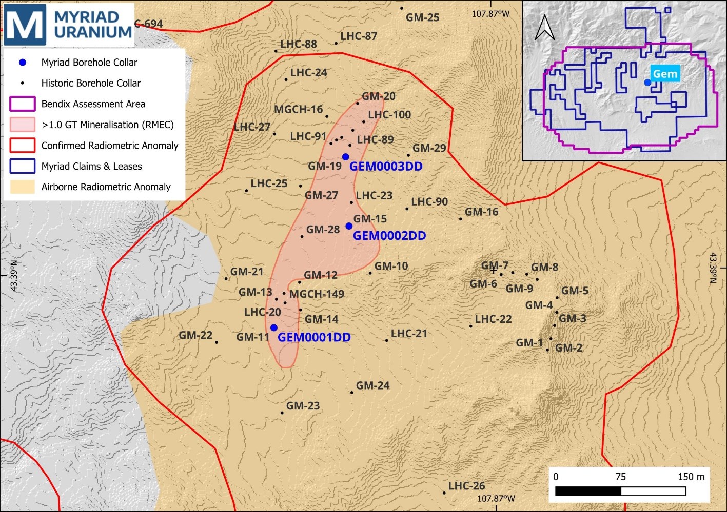
Figure 1: Drilled locations at Gem
To view an enhanced version of this graphic, please visit:
https://images.newsfilecorp.com/files/6301/313785_35b2713204481bb0_002full.jpg
Downhole Logging
Downhole logging was undertaken by Century Geophysical (Century), a respected downhole probe manufacturer and logging company based in Tulsa, Oklahoma and in business since 1946. Century deployed their “Uranium E-Log Suite”, which includes Natural Gamma Ray, Resistivity, Spontaneous Potential (S.P.) and Deviation probes. Borehole deviations were additionally measured using a Gyro Deviation tool, which is unaffected by magnetic influence. Century delivered data in electronic format for each hole including log plots and calculated equivalent uranium grades.
Equivalent Uranium Grade Calculations
Century uses its OREGRADE system to convert raw gamma-ray logs into uranium grade estimates expressed as eU3O8. The process relies on a trial-and-error iterative deconvolution algorithm to model the distribution of radioactivity from gamma-ray log data. Raw gamma counts are normalized and corrected for borehole conditions by applying dead time correction, geometric multipliers for area-based K-factors and linear depth, and environmental corrections such as water factor below the water table and casing factor within cased sections. The system uses synthetic log creation and iterative interval calculations to estimate eU3O8 grades over 15 cm (0.5 foot) intervals. The final output is a grade curve and a printed report that identifies distinct zones and calculates cut-off analyses and best intervals based on grade-thickness product. These estimates remain subject to the limitations of gamma logging and confirmation by laboratory assays.
Historical Resource Estimates
The historical estimate for Gem of 1.44 Mlbs eU3O8 in 3.07 Mt at 234 ppm eU3O8, using a 100 ppm cut-off, was compiled from internal Rocky Mountain Energy Company reports, which are summarised in a report titled “Copper Mountain Exploration Project Report” by Southard, G.G., et. al. (1979). This forms part of the overall historical estimate for Copper Mountain of 26.63 Mlbs eU3O8 in 48.95 Mt at 269 ppm eU3O8, using a 100 ppm cut-off, was compiled from internal Rocky Mountain Energy Company reports, which are summarised in a report titled “Copper Mountain Exploration Project Report” by Southard, G.G., et. al. (1979). A Qualified Person has not done sufficient work to classify the historical estimate as current mineral resources or mineral reserves, and Myriad is not treating the historical estimate as current mineral resources or mineral reserves.
The historical estimates were completed using polygonal methods based on modelled mineralization geometries. The historical estimates used U.S. Bureau of Mines categories at the time, including terms described as “Inferred” and “Indicated,” which are not current CIM terminology and should not be interpreted as current mineral resource categories. Details of the historical resource estimates are available in the current NI 43-101 Technical Report. While the QP has determined that the historical estimates described in this news release are relevant to the Copper Mountain Project Area, are reasonably reliable given the authors and circumstances of their preparation, and are suitable for public disclosure, the estimates are decades old and based on drilling data for which the logs are, as of yet, predominantly unavailable. Readers are cautioned not to place undue reliance on these historical estimates as an indicator of current mineral resources or mineral reserves at the Project Area. Also, while the Copper Mountain Project Area contains all or most of each deposit referred to, some of the resources referred to may be located outside the current Copper Mountain Project Area.
Inherent limitations of the historical estimates include that the nature of mineralization (fracture hosted) makes estimation from drill data less reliable than other deposit types (e.g. those that are thick and uniform). From Myriad Uranium’s viewpoint, limitations include that the Company has not been able to verify the original data itself and that the estimates may be optimistic relative to subsequent work which applied a “delayed fission neutron” (DFN) factor to calculate grades. On the other hand, DFN is controversial, in that the approach is viewed by some experts as too conservative. Nevertheless, it was applied in later resource estimations by Union Pacific relating to Copper Mountain. To verify the historical estimates and re-state them as current resources, a program of re-drilling is required to generate new data that can be used to establish the correlation and continuity of geology and grades between boreholes with sufficient confidence to estimate mineral resources.
Exploration Target
The Exploration Target of 1,111 to 2,971 Mt at 100 ppm eU3O8 or 222 to 594 Mt at 500 ppm eU3O8, is based on an assessment completed by the Bendix Field Engineering Corporation (“Bendix”) in 1982 on behalf of the U.S Department of Energy (“DOE”). The methodology and outcomes of the study were detailed in two reports, namely “An Exploration Systems Approach to the Copper Mountain Area Uranium Deposits, Central Wyoming” (Hennesy, September 1982), and “Copper Mountain, Wyoming, Intermediate-Grade Uranium Resource Assessment Project Final Report” (Sayala et. al., November 1982). Details of the Exploration Target are available in the current NI 43-101 Technical Report.
Bendix relied on a vast amount of information for their assessment. The information was a combination of data provided by Union Pacific and data collected by Bendix. This included detailed geological studies (general geology, tectono-depositional analysis, structure and metallogeny), surface geochemical studies (lithogeochemical, soil and stream surveys), subsurface geochemical studies (drilling, spectral radiometric probing and core geochemistry), geophysics (radiometric, magnetic and electrical methods) and emanometric (helium and radon) studies. Seven holes (CM-series) were drilled by Bendix in and around the Canning deposit. The data from a further 1,193 holes drilled by RMEC in the Control Area was also supplied to Bendix for their studies.
The data was used to develop a genetic model for uranium mineralisation in the Precambrian and Eocene sedimentary host rock environments, and to develop a structural scoring system in the high-confidence control area to establish the basis for estimations of uranium mineralisation endowment in the total Assessment Area. The model ultimately relied on the relationship between structure and uranium mineralisation, which is the primary style of mineralisation control in granite at Copper Mountain. The scoring system developed for structural favourability (aside from favourable granitic host rock) was based on the following parameters and their potential contribution to structural preparation: 1) the presence of a graben(s); 2) the presence of a major east-west-trending fault zone(s); 3) the presence of fault intersections; 4) the presence of variously oriented subsidiary faults; and 5) positioning along a known or inferred favourable structural trend. The scoring system was applied across the Control Area and compared with known deposit locations.
The QP considers the methodology and basis on which the target range has been estimated to be appropriate and relevant for Myriad’s own exploration planning. The potential quantity and grade of the Exploration Target are conceptual in nature, there has been insufficient exploration to define a mineral resource, and it is uncertain whether further exploration will result in the Exploration Target being delineated as a mineral resource.
Qualified Person
The scientific and technical information in this news release, including the eU3O8 methodology and historical disclosure, has been reviewed and approved by George van der Walt, MSc., Pr.Sci.Nat., FGSSA, a “Qualified Person” as defined under NI 43-101. Mr. van der Walt is a Principal Consultant with The MSA Group (Pty) Ltd, an independent consultancy, and is independent of the Company for the purposes of NI 43-101. A Qualified Person has not done sufficient work to verify historical exploration results or to classify the historical estimates referred to in this news release as current mineral resources or mineral reserves, and Myriad is not treating such historical estimates as current mineral resources or mineral reserves.
About Myriad Uranium Corp.
Myriad Uranium Corp. holds a 100% interest in the Copper Mountain Uranium Project in Wyoming, USA. Copper Mountain hosts multiple historic uranium deposits and past-producing mines, including the Arrowhead Mine (approximately 500,000 lbs U₃O₈ produced). Union Pacific conducted extensive exploration and development in the district during the late 1970s, including approximately 2,000 boreholes and advanced mine planning, before the uranium market downturn in 1980. Union Pacific is estimated to have invested approximately C$125 million (2026 dollars) in the project, generating significant historical resource estimates.
A news release detailing a comprehensive assessment of Copper Mountain’s uranium endowment by Bendix Engineering for the US Department of Energy published in 1982 can be viewed here.
Myriad holds a 10% free carried interest in the Red Basin Uranium Project, recently sold to 8VC- and Overmatch-backed Subatomic Industries. Red Basin carries significant historical resource estimates from extensive drilling by Occidental Oil in the late 1970s, and also hosts vanadium, which has been designated a strategic and critical mineral by the U.S. government. Note the caution on historical estimates below.
Myriad’s 100%-owned Breccia Pipe Project in Arizona comprises at least 23 breccia pipes that are prospective for uranium and REEs. One of the pipes, the Wate Pipe, was previously owned and explored by Energy Fuels and is the subject of a historical resource estimate.
Note: A qualified person has not done sufficient work to classify the Copper Mountain, Red Basin, and Breccia Pipe Project historical estimates as current mineral resources or reserves and Myriad is not treating historical estimates as current resources or reserves. Myriad intends to conduct further work to determine whether the historical estimates can be verified and, if appropriate, supported by current mineral resource estimates.
For further information, please refer to Myriad’s disclosure record on SEDAR+ (www.sedarplus.ca), contact Myriad by telephone at +1.604.418.2877, or refer to Myriad’s website at www.myriaduranium.com.
Myriad Contacts:
Thomas Lamb
President and CEO
Forward-Looking Statements
This news release contains “forward-looking information” that is based on the Company’s current expectations, estimates, forecasts and projections. This forward-looking information includes, among other things, the Company’s business, plans, outlook and business strategy. The words “may”, “would”, “could”, “should”, “will”, “likely”, “expect”, “anticipate”, “intend”, “estimate”, “plan”, “forecast”, “project” and “believe” or other similar words and phrases are intended to identify forward-looking information. The reader is cautioned that assumptions used in the preparation of any forward-looking information may prove to be incorrect, including with respect to the Company’s business plans respecting the exploration and development of the Company’s mineral properties, the proposed work program on the Company’s mineral properties and the potential and economic viability of the Company’s mineral properties. Forward-looking information is subject to known and unknown risks, uncertainties and other factors that may cause the Company’s actual results, level of activity, performance or achievements to be materially different from those expressed or implied by such forward-looking information. Such factors include, but are not limited to: inability to verify historical data, no assurance of defining mineral resources, permitting, drilling delays and changes in economic conditions or financial markets; increases in costs; litigation; legislative, environmental and other judicial, regulatory, political and competitive developments; and technological or operational difficulties. This list is not exhaustive of the factors that may affect our forward-looking information. These and other factors should be considered carefully, and readers should not place undue reliance on such forward-looking information. The Company does not intend, and expressly disclaims any intention or obligation to, update or revise any forward-looking information whether as a result of new information, future events or otherwise, except as required by applicable law. The CSE has not reviewed, approved or disapproved the contents of this news release.
APPENDIX 1: Preliminary eU3O8 Grade Interval Summaries at 100, 200 and 500 ppm thresholds
Reported intervals are downhole lengths; true widths have not yet been determined.
| 100 ppm Threshold | Peak Grade | Depth | |||||
| Hole ID | From (m) | To (m) | Length (m) | eU3O8 (ppm) | eU3O8 (%) | (eU3O8 ppm) | (m) |
| GEM0001DD | 14.37 | 31.14 | 16.76 | 166 | 0.017 | 471 | 23.1 |
| GEM0001DD | 37.69 | 38.60 | 0.91 | 113 | 0.011 | 130 | 38.4 |
| GEM0001DD | 43.17 | 72.59 | 29.41 | 295 | 0.030 | 647 | 45.8 |
| GEM0001DD | 87.37 | 88.44 | 1.07 | 112 | 0.011 | 122 | 87.6 |
| GEM0001DD | 102.76 | 103.37 | 0.61 | 184 | 0.018 | 241 | 103.1 |
| GEM0002DD | 6.84 | 9.43 | 2.59 | 159 | 0.016 | 228 | 7.2 |
| GEM0002DD | 10.65 | 45.55 | 34.90 | 210 | 0.021 | 1368 | 16.1 |
| GEM0002DD | 107.43 | 108.95 | 1.52 | 113 | 0.011 | 146 | 108.7 |
| GEM0003DD | 10.01 | 12.15 | 2.13 | 116 | 0.012 | 141 | 12.1 |
| GEM0003DD | 14.58 | 15.65 | 1.07 | 145 | 0.015 | 220 | 15.3 |
| GEM0003DD | 22.66 | 55.89 | 33.22 | 235 | 0.024 | 603 | 28.4 |
| GEM0003DD | 58.17 | 58.78 | 0.61 | 236 | 0.024 | 327 | 58.4 |
| GEM0003DD | 60.30 | 70.36 | 10.06 | 161 | 0.016 | 360 | 64.8 |
| GEM0003DD | 71.58 | 73.56 | 1.98 | 160 | 0.016 | 215 | 72.1 |
| GEM0003DD | 76.61 | 77.98 | 1.37 | 172 | 0.017 | 226 | 77.1 |
| GEM0003DD | 86.06 | 86.97 | 0.91 | 302 | 0.030 | 700 | 86.6 |
| 200 ppm Threshold | Peak Grade | Depth | |||||
| Hole ID | From (m) | To (m) | Length (m) | eU3O8 (ppm) | eU3O8 (%) | (eU3O8 ppm) | (m) |
| GEM0001DD | 21.23 | 24.73 | 3.51 | 285 | 0.028 | 471 | 23.1 |
| GEM0001DD | 26.87 | 27.48 | 0.61 | 268 | 0.027 | 301 | 27.2 |
| GEM0001DD | 45.46 | 46.22 | 0.76 | 457 | 0.046 | 647 | 45.8 |
| GEM0001DD | 48.05 | 56.13 | 8.08 | 326 | 0.033 | 541 | 52.7 |
| GEM0001DD | 57.50 | 67.71 | 10.21 | 365 | 0.037 | 528 | 61.7 |
| GEM0001DD | 69.39 | 71.98 | 2.59 | 339 | 0.034 | 438 | 71.1 |
| GEM0002DD | 11.11 | 12.79 | 1.68 | 233 | 0.023 | 276 | 12.1 |
| GEM0002DD | 15.07 | 17.82 | 2.74 | 616 | 0.062 | 1368 | 16.1 |
| GEM0002DD | 22.69 | 25.59 | 2.90 | 301 | 0.030 | 636 | 23.8 |
| GEM0002DD | 30.46 | 31.68 | 1.22 | 259 | 0.026 | 339 | 30.8 |
| GEM0002DD | 38.69 | 39.91 | 1.22 | 239 | 0.024 | 278 | 39.2 |
| GEM0003DD | 23.42 | 26.47 | 3.05 | 274 | 0.027 | 493 | 25.9 |
| GEM0003DD | 27.23 | 38.82 | 11.58 | 308 | 0.031 | 603 | 28.4 |
| GEM0003DD | 40.49 | 41.25 | 0.76 | 206 | 0.021 | 214 | 40.6 |
| GEM0003DD | 42.17 | 45.37 | 3.20 | 275 | 0.028 | 383 | 43.3 |
| GEM0003DD | 46.28 | 47.05 | 0.76 | 375 | 0.038 | 496 | 46.7 |
| GEM0003DD | 47.35 | 48.27 | 0.91 | 267 | 0.027 | 305 | 47.7 |
| GEM0003DD | 62.74 | 63.66 | 0.91 | 241 | 0.024 | 301 | 63.1 |
| GEM0003DD | 86.37 | 86.82 | 0.46 | 484 | 0.048 | 700 | 86.6 |
| 500 ppm Threshold | Peak Grade | Depth | |||||
| Hole ID | From (m) | To (m) | Length (m) | eU3O8 (ppm) | eU3O8 (%) | (eU3O8 ppm) | (m) |
| GEM0002DD | 15.83 | 17.05 | 1.22 | 1027 | 0.103 | 1368 | 16.1 |
1 A Qualified Person has not done sufficient work to classify the historical estimate as current mineral resources or mineral reserves, and Myriad is not treating the historical estimate as current mineral resources or mineral reserves. See note about historical estimates.
2 The potential quantity and grade of the Exploration Target are conceptual in nature, there has been insufficient exploration to define a mineral resource, and it is uncertain whether further exploration will result in the Exploration Target being delineated as a mineral resource.